Luggie Aqueduct
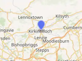
The Luggie Aqueduct carries the Forth & Clyde Canal over the Luggie Water at Kirkintilloch,[1] to the north of Glasgow.[2]It is a Category A listed building.[3]
Luggie Aqueduct | |
|---|---|
 | |
| Coordinates | 55°56′23″N 4°09′04″W |
| Carries | Forth & Clyde Canal |
| Crosses | Luggie Water |
| Heritage status | Category A listed |
| Location | |
| |
History
It was built by John Smeaton for the Forth and Clyde Canal between 1768-75.[4]
Design
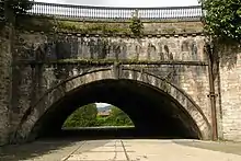
The aqueduct is 37.8 metres (124 ft) long with a single arch span of 13.7 metres (45 ft), and 27.4 metres (90 ft) wide, with a full width canal that allows two boats to pass.[4][5]
In 1848, the Campsie Branch line was constructed, and crossed the canal through the arch of the aqueduct but above the water beneath.[4] The railway was carried on a twin-arch culvert to carry the water underneath it.[4] The railway has since been removed, and there is now a footpath beneath the aqueduct but with the lines of the rails still visible.[3] There is an old black and white picture of a boat crossing the canal, with a train passing underneath the boat, with the Luggie flowing below the train.[6]
The sides of the aqueduct are arched, with a rise of about 1 in 10, a feature also employed on the Kelvin Aqueduct.[4][7] The aqueduct and the bridge below are built from grey ashlar.[3]
References
- "Dumbartonshire 033.02 (includes: Campsie; Kirkintilloch) 1898". National Library of Scotland. O.S. Retrieved 10 August 2016.
- "Luggie Aqueduct". forgottenrelics.co.uk. Retrieved 19 December 2014.
- Historic Environment Scotland. "Luggie Water Aqueduct and Bridge (Category A Listed Building) (LB36655)". Retrieved 28 March 2019.
- "Site Record for Forth And Clyde Canal, Kirkintilloch, Luggie Water Aqueduct". canmore.rcahms.gov.uk. Retrieved 19 December 2014.
- "Luggie Aqueduct". engineering-timelines.com. Retrieved 17 December 2014.
- https://archive.org/stream/kirkintillochtow00wats#page/168/mode/2up Kirkintilloch, Town and Parish pg 169
- Google (19 December 2014). "Luggie Aqueduct" (Map). Google Maps. Google. Retrieved 19 December 2014.
External links
| Wikimedia Commons has media related to Luggie Aqueduct. |