Lukovo Point
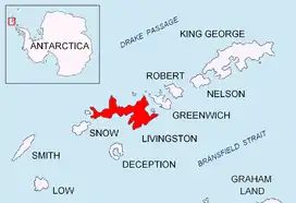
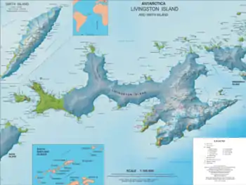
Lukovo Point (Bulgarian: нос Луково, ‘Nos Lukovo’ \'nos 'lu-ko-vo\) is the mostly ice-free point on the northwest coast of South Bay in Livingston Island, Antarctica projecting 200 m southwards. It is surmounted by Krakra Bluff on the north. The feature is named after the settlements Lukovo in Western Bulgaria, and Gorno (Upper) and Dolno (Lower) Lukovo in Southern Bulgaria.
Location
Lukovo Point is located at 62°38′38.7″S 60°33′24″W, which is 1.8 km northeast of Aldan Rock, 3.15 km east-northeast of Hannah Point, 5 km west-southwest of Ereby Point and 10.5 km northwest of Miers Bluff. British mapping in 1968, and Bulgarian in 2005, 2009 and 2017.
Maps
- L.L. Ivanov et al. Antarctica: Livingston Island and Greenwich Island, South Shetland Islands. Scale 1:100000 topographic map. Sofia: Antarctic Place-names Commission of Bulgaria, 2005.
- L.L. Ivanov. Antarctica: Livingston Island and Greenwich, Robert, Snow and Smith Islands. Scale 1:120000 topographic map. Troyan: Manfred Wörner Foundation, 2009.
- Antarctic Digital Database (ADD). Scale 1:250000 topographic map of Antarctica. Scientific Committee on Antarctic Research (SCAR). Since 1993, regularly upgraded and updated
References
- Bulgarian Antarctic Gazetteer. Antarctic Place-names Commission. (details in Bulgarian, basic data in English)
- Lukovo Point. SCAR Composite Gazetteer of Antarctica
External links
- Lukovo Point. Copernix satellite image
This article includes information from the Antarctic Place-names Commission of Bulgaria which is used with permission.