Mánfa
Mánfa | |
|---|---|
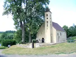 Sarlós Boldogasszony Church of Mánfa | |
 Coat of arms | |
 Mánfa Location of Mánfa in Hungary | |
| Coordinates: 46°09′30″N 18°14′26″E | |
| Country | Hungary |
| Region | Southern Transdanubia |
| County | Baranya |
| Subregion | Komlói |
| Rank | Village |
| Area | |
| • Total | 27.70 km2 (10.70 sq mi) |
| Population (1 January 2008)[2] | |
| • Total | 896 |
| • Density | 32/km2 (84/sq mi) |
| Time zone | UTC+1 (CET) |
| • Summer (DST) | UTC+2 (CEST) |
| Postal code | 7304 |
| Area code | +36 72 |
| KSH code | 33923[1] |
| Website | www.manfa.hu |
Mánfa is a village in Baranya county, Hungary.
Settings
Mánfa is situated in the Mecsek Mountain sin Southern Hungary. It can be reached by car along the No. 66 highway in the Kaposvár–Sásd–Magyarszék–Pécs line.
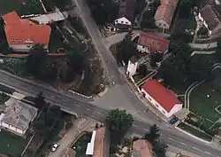
Mánfa: aerial photograph
History
The village is an old foundation from the Árpád age. In 1949 another village, Budafa was attached to it, and the united village was attached to the town of Komló, a mining town near Pécs. In 1991 people of Mánfa voted to separate from Komló and recently Mánfa is an independent village.
Sightseeings
- The Árpád age romanesque church consecrated to Our Lady (Sarlós Boldogasszony).
References
- Mánfa at the Hungarian Central Statistical Office (Hungarian).
- Mánfa at the Hungarian Central Statistical Office (Hungarian). 1 January 2008
- Gerevich Tibor: Magyarország románkori emlékei. (Die romanische Denkmäler Ungarns.) Egyetemi nyomda. Budapest, 1938.
External links
This article is issued from Wikipedia. The text is licensed under Creative Commons - Attribution - Sharealike. Additional terms may apply for the media files.