Ma'amtagila First Nation
The Ma'amtagila First Nation, formerly known as Mahteelthpe or Matilpi Tribe, are an Indigenous nation and part of the Kwakwaka'wakw peoples. Their territory is located in the Queen Charlotte Strait-Johnstone Strait area in the Discovery Islands between Vancouver Island and the British Columbia mainland in Canada.
The Ma'amtagila are recognized by the various tribes that comprise the Kwakwaka'wakw-speaking peoples.[1] In 1945, the Ma'mtagila amalgamated with the Tlowitsis First Nation to create the Tlowitsis-Mumtagila First Nation. In 1998, the name was simplified.[2]
History
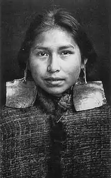
Prior to contact with settlers, the Ma'amtagila occupied the area around what is now called the Johnstone Strait for thousands of years. Their primary dwelling places were Etsekin (Matilpi Village) and Haylate, locations that were central to the overall territories of the Kwakwaka'wakw people. Like all Kwakwaka'wakw, the Ma’amtagila are made up of several namimas (clans), each with its own Eagle seat (leader). The three main namimas of the Ma’amtagila are the Hamatam (Seagull), Gixsam (Kulus, Thunderbird) and the Hayalikawa’yi (Healers). The Ma’a̱mtagila name derives from their ancestor, Matagila, the grey seagull. The Ma'amtagila are known for their harvesting and carving of Cedar trees, as well as their silverwork.[3]
Post-Contact
In 1886, the Dominion of Canada recognized the existence of the Ma'amtagila,[4] then called the Mahteelthpe or Matilpi Tribe. In 1902, the band was allotted 145 acres of reserve land.[5] In 1914, the Royal Commission on Indian Affairs in British Columbia visited with the members of the "Mahteelthpe" Tribe.[6] Chief Lagis addressed the commissioners, speaking on behalf of the community:
I am glad to meet you for this reason that we are so much in trouble about our lands. There are hardly any of my lands left now for our use — it is all taken by the whites —it is given to them by the people from whom you come. There are only a few cedar trees left now — all the other trees are gone now; namely the fir trees all have been cut down by the whites. Many booms of logs have been taken away from my lands; so many of them that I don't know the number of them. My forefathers have never received anything from the Government for these lands — at least if they did I don't know anything about it. I don't think they have received anything for it. These lands belong to our forefathers, and therefore belong to me and my children, and I want to put forth my hand to pull some of it back as it looks like as if the Government wants it wrenched out of our hands. Those lands, as I said before belong to my forefathers, and therefore we say it is our own.
In its final report issued in 1916,[7] the commission confirmed six reserves of the "Mahteelthpe or Matilipi Tribe":
- No. 1: Etsekin
- No. 2: Keecokiltum (Port Harvey)
- No. 3: Haylahte
- No. 4: Harkom (Port Neville)
- No. 5: Pawala
- No 6: Hanatsa
According to the commission's final report, the village of Etsekin was largely abandoned due to a smallpox outbreak in the 1880s. These six reserves were confirmed in the 1943 Schedule of Indian Reserves in the Dominion of Canada.[8]
Amalgamation with the Tlowitsis First Nation
In 1945, the Matilpi Tribe amalgamated with the nearby Klowitsis Tribe, to create the Turnour Island Tribe.[9] The amalgamation was ordered by the Indian Agent, in order to make the management of these two smaller tribes easier. Members of the Matilpi agreed to join the Klowitsis Tribe with the understanding that their two chiefs would govern "with equal powers and responsibilities." In 1983, the name was changed to the Tlowitsis-Mumtagila First Nation, in order to more accurately reflect the Indigenous titles.
Over time, the relationship between the Tlowitsis and Ma'amtagila members became contentious. In 1998, the Tlowitsis leadership removed 'Mumtagila' from the group's name to leave only Tlowitsis First Nation.[10] In the band council resolution, Chief John Smith declared that the Matilpi/Ma'amtagila "ceded title and authority to their lands to the chiefs of the Tlowitsis." The Ma'amtagila dispute this claim.
UVic Little Big House Campaign
In 2019, members of the Ma'amtagila partnered with the University of Victoria to build a Little Big House.[11] The construction of the Little Big House is part of an assertion of Indigenous sovereignty spear-headed by Ma’amtagila matriarch Tsastilqualus Ambers Umbas, in coordination with broader Kwakwaka'wakw hereditary leadership. Tsastilqualus and other members of the Matriarch Camp intend to return home to their lands and waters near Hiladi, “the place to make things right,” to affirm their Indigenous title and rights and uphold hereditary systems of governance.
According to the group's website:
The portable Little Big House will enable Tsastilqualus, her son Dakota, their kin, and other Indigenous people to spend time on the land and water. In the process, the Little Big House will help to reinvigorate land-based cultural and spiritual practices, strengthen matriarchal decision-making practices that are integral to Kwakwaka'wakw governance, increase access to traditional foods and medicines, and (re)produce and share knowledge with younger generations. However, Ma’amtagila and Kwakwaka'wakw territories and people are also facing the impacts of historical and ongoing colonial violence. The Little Big House will facilitate anti-colonial resistance efforts by serving as a base of operations for the Wild Salmon Matriarch Camp, who witness and document industrial activity and initiate campaigns to oppose unsustainable logging and fish farming practices that threaten the health and well-being of all life on Ma’amtagila territory. The Little Big House will support Ma’amtagila people as they uphold their responsibilities and make things right.[12]
At the launch of the campaign, Ma'amtagila member and UVic student Matt Ambers said, “Right now, we’re removed. We’re not on the land. But if we start to move back to the land, and start to utilize our resources again, it becomes very hard for them to continue to take what is ours.”[13]
Treaty process
The Ma'amtagila have never entered into treaty negotiations with the Government of Canada and their territory remains unceded.[14]
See also
- List of Kwakwaka'wakw villages
- Kwak'wala (language)
References
- U'mista Cultural Society, Synthescape Art Imaging (2015-11-01). "Our Land | Our People | Living Tradition, The Kwakwaka'wakw Potlatch on the Northwest Coast". umistapotlatch.ca. Retrieved 2019-10-17.
- "Tlowitsis Tribe | BC Assembly of First Nations". Retrieved 2019-03-06.
- "Indigenous Collections". Royal BC Museum Archives. Retrieved October 17, 2019.
- "Historical Atlas of Canada Online Learning Project". neptis.geog.utoronto.ca. Retrieved 2019-10-17.
- "Historical Atlas of Canada Online Learning Project". neptis.geog.utoronto.ca. Retrieved 2019-10-17.
- "Kwawkewlth Agency: Meeting with the Mah-teel-th-pe Band". Our Homes Are Bleeding | Union of BC Indian Chiefs. Retrieved 2019-10-17.
- Government of Canada, Public Services and Procurement Canada (2002-07-01). "[Report of the Royal Commission on Indian Affairs for the Province of British Columbia] .: Z1-1912/6E-PDF - Government of Canada Publications - Canada.ca". publications.gc.ca. Retrieved 2019-10-17.
- "SCHEDULE OF INDIAN RESERVES IN THE DOMINION OF CANADA PART 2 RESERVES IN THE PROVINCE OF BRITISH COLUMBIA RECOMPILED AND CORRECTED UP TO MARCH 31, 1943". Library and Archives Canada. Retrieved October 17, 2019.
- "AMALGAMATION - KLAWATSIS AND MATILPI BANDS - TO - TURNOUR ISLAND BAND". Library and Archives Canada, bac-lac.gc.ca. Retrieved October 17, 2019.
- "Tlowitsis Tribe | Assembly of First Nations". Retrieved October 17, 2019.
- "UVic Little Big House Build". www.facebook.com. Retrieved 2019-10-17.
- "UVic Little Big House Build". www.facebook.com. Retrieved 2019-10-17.
- Simpson, Natasha (2019-10-04). "Little Big House to be a base for environmentalist, anti-colonialist movement". The Martlet | University of Victoria. Retrieved 2019-10-18.
- "Interactive Map | BC Treaty Commission". www.bctreaty.ca. Retrieved 2019-10-17.
| Tribes or Nations |
|  |
|---|---|---|
| First Nations |
| |
| Villages | ||
| Culture & Society | ||