MacCarthy Island
MacCarthy Island, also known as Lemain Island or Janjanbureh Island, is an island located approximately 170 miles (272 km) upriver from the mouth of the Gambia River, in eastern Gambia, in the Central River Division. The town of Janjanbureh on the island is the second largest in the country, though it still appears on many maps by its European name of Georgetown. In addition to being a destination for some wildlife tourists, it is also the home of Gambia's largest prison.
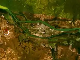 Satellite image of MacCarthy Island | |
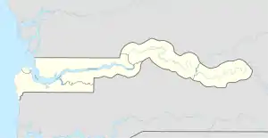 MacCarthy Island | |
| Geography | |
|---|---|
| Location | Gambia River |
| Coordinates | 13.535°N 14.765°W |
| Length | 10 km (6 mi) |
| Width | 2.5 km (1.55 mi) |
| Administration | |
| Largest settlement | Janjanbureh (pop. 3,446[1]) |
| Demographics | |
| Population | 3,998[2] |
| Ethnic groups | Mandinka, Wolof, Fulani |
History
The island was first settled by Western traders in the 15th century, though by the 19th century it was no longer a viable trading post due to frequent wars between the Wulli and Niani tribes. The island was subsequently purchased by the British to use as a military garrison to help protect the traders. A treaty of cession was signed in 1823 and the island was formally named MacCarthy Island (after Sir Charles MacCarthy, former Governor General of the British West African Territories.) In 1832, Georgetown was founded by the British as a Creole settlement, though it was quickly populated by liberated Africans from elsewhere. The town gradually became an administrative and economic centre for the country
References
- "Georgetown The Gambia". Encyclopædia Britannica. Retrieved 25 July 2015.
- "District of Janjanbureh". Gambia Bureau of Statistics. Archived from the original on 26 July 2015. Retrieved 25 July 2015.
External links
| Authority control |
|
|---|