Malčius
The Malčius is a river of Kėdainiai district municipality, Kaunas County, central Lithuania. It flows for 18.3 kilometres (11.4 mi) and has a basin area of 51.3 square kilometres (19.8 sq mi). It starts in the Lančiūnava-Šventybrastis Forest and flows mostly southwards. It meets the Obelis river (from the right side) by Aristavėlė village.
| Malčius | |
|---|---|
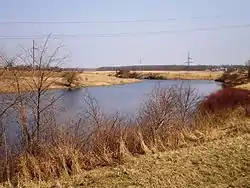 The lower course of the Malčius (the Malčius Pond) | |
| Location | |
| Country | Lithuania |
| Region | Kėdainiai district municipality, Kaunas County |
| Physical characteristics | |
| Source | |
| • location | Lančiūnava-Šventybrastis Forest |
| Mouth | Obelis (Juodkiškiai Reservoir) in Aristavėlė |
• coordinates | 55°17′25″N 24°3′21″E |
| Length | 18.3 km (11.4 mi)[1] |
| Basin size | 51.3 km2 (19.8 sq mi)[1] |
| Basin features | |
| Progression | Obelis→ Nevėžis→ Neman→ Baltic Sea |
| Tributaries | |
| • left | Drigantas |
All the course is channelized. Malčius passes through Pliupai, Stebuliai, Katkai, Aristava and Aristavėlė villages. Several ponds (Malčius, Aristavėlė 1st, Aristavėlė 2nd) are on the Malčius river.
The hydronym derives from Lithuanian verbs malšyti, malšinti ('to still, to quieten'), malšti ('to become still, to relent').[2]
References
| Wikimedia Commons has media related to Malčius. |
- B. Gailiušis, J. Jablonskis, M Kovalenkovienė (2001). Lietuvos upės (in Lithuanian). Kaunas: Lietuvos energetikos institutas. p. 507.CS1 maint: multiple names: authors list (link)
- Vanagas, Aleksandras (1981). Lietuvių hidronimų etimologinis žodynas (in Lithuanian). Vilnius: Mokslas.
This article is issued from Wikipedia. The text is licensed under Creative Commons - Attribution - Sharealike. Additional terms may apply for the media files.