Manicouagan Uapishka Biosphere Reserve
The landscape of the Manicouagan – Uapishka Biosphere Reserve is dominated by the Saint Lawrence River to the south and the Manicouagan reservoir to the north, forming a circle visible from great distances, even from space. They are linked by a web of rivers, which flow through vast woodlands.[1]
| Manicouagan Uapishka Biosphere Reserve | |
|---|---|
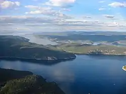 Aerial view of Manicouagan Reservoir and the surrounding forests | |
  | |
| Location | Quebec, Canada |
| Coordinates | 49°14′24″N 68°08′24″W |
| Established | 2007 |
| Governing body | Réserve Mondiale de la Biosphère Manicouagan – Uapishka (RMBMU) |
Ecological Characteristics
The Manicouagan – Uapishka Biosphere Reserve is a testament to some of the most powerful phenomena the Earth has ever known. It was formed by the patient erosion of millions of years, combined with the collision of a huge meteorite, the crushing passage of glaciers and an ancient sea that smoothed the land. The impact of the meteorite formed the crater and circular lake that characterize this biosphere reserve.
The hinterland of the Manicouagan – Uapishka area consists of a vast dry plateau. Its surface is formed by hills ranging between 400 m and 600 m, separated by rectilinear valleys and surrounded by the Groulx Mountains massif, which is characterized by about 30 mountains over 1000 m in height.
The salt marshes of the Manicouagan – Uapishka reserve are among the most productive habitats on the planet, acting as important resting places for more than 200 migratory birds. Fauna characteristic of boreal forests in the area include the vulnerable boreal woodland caribou (Rangifer tarandus caribou), cougar (Puma concolor), least weasel (Mustela nivalis), short-eared owl (Asio flammeus), golden eagle (Aquila chrysaetos), and the threatened wolverine (Gulo gulo) and beluga whale (Delphinapterus leucas).[1]
Socio-Economic Characteristics
The largest city in the area is Baie-Comeau with a population just under 23,000. The main economic activities include timber transformation, agriculture, aluminum production, mining, commercial fisheries and merchant shipping. A huge hydroelectric power plant also creates employment opportunities.
The area also contains an Innu reserve with a resident population of about 2,500 inhabitants. The Manicouagan population along the coastline has over time become almost exclusively French with the descendants of ancient Indigenous families living on the Pessamit reserve.[1]
References
- "Manicouagan Uapishka | United Nations Educational, Scientific and Cultural Organization". www.unesco.org. Retrieved 2016-06-14.
Sources
![]() This article incorporates text from a free content work. License statement/permission on Wikimedia Commons. Text taken from UNESCO - MAB Biosphere Reserves Directory, UNESCO, UNESCO.
This article incorporates text from a free content work. License statement/permission on Wikimedia Commons. Text taken from UNESCO - MAB Biosphere Reserves Directory, UNESCO, UNESCO.