Marshland Rural District
Marshland Rural District was a rural district in Norfolk, England from 1894 to 1974.[1]
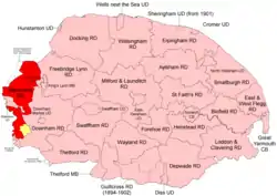 Position within Norfolk, 1894 Boundaries in 1894. 1930 reduction in yellow. |
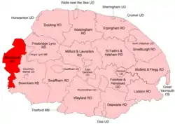 Position within Norfolk, 1935 Boundaries in 1935 |
It was formed under the Local Government Act 1894 based on the Marshland rural sanitary district, and was named after the Freebridge Marshland hundred. It covered an area to the west of King's Lynn on the borders of Lincolnshire and the Isle of Ely.
In 1930 a new parish of Nordelph was created in Downham RD, taking land mostly out of the Marshland RD parishes of Upwell and Outwell.[2]
During the period 1933-1935 it absorbed most of the area of the disbanded Walsoken Urban District[3], with other minor boundary changes[1].
In 1974, the district was abolished under the Local Government Act 1972, and became part of the West Norfolk district.
Statistics
| Year | Area (ha) [4] |
Population [5] |
Density (pop/ha) |
|---|---|---|---|
| 1911 | 22,085 | 12,382 | 0.56 |
| 1921 | 15,589 | 0.71 | |
| 1931 | 20,676 | 14,130 | 0.68 |
| 1951 | 22,890 | 16,570 | 0.72 |
| 1961 | 16,994 | 0.74 |
Parishes
| Parish | From | To | Notes |
|---|---|---|---|
| Clenchwarton | |||
| Emneth | |||
| Marshland St James | 1935 | Created from parts of 11 parishes | |
| Outwell | |||
| Terrington St Clement | |||
| Terrington St John | |||
| Tilney All Saints | |||
| Tilney St Lawrence | |||
| Tilney with Islington | 1935 | Most to Tilney St Lawrence, some to Marshland St James | |
| Upwell | |||
| Walpole St Andrew | |||
| Walpole St Peter | |||
| Walsoken | 1934 | Previously Walsoken UD | |
| West Walton |
References
- "Marshland RD through time: Census tables with data for the Local Government District". A Vision of Britain through Time. GB Historical GIS / University of Portsmouth. Retrieved 24 June 2017.
- "Upwell CP through time: Population Statistics: Area (acres)". A Vision of Britain through Time. GB Historical GIS / University of Portsmouth. Shows reduction in Upwell between 1921 & 1931. Note that several other pages on the site fail to report this transfer. Retrieved 26 June 2017.
- "Walsoken AP/CP through time: Census tables with data for the Local Government District". A Vision of Britain through Time. GB Historical GIS / University of Portsmouth. Retrieved 24 June 2017.
- "Marshland RD through time: Population Statistics: Area (acres)". A Vision of Britain through Time. GB Historical GIS / University of Portsmouth. Retrieved 26 June 2017.
- "Marshland RD through time: Population Statistics: Total Population". A Vision of Britain through Time. GB Historical GIS / University of Portsmouth. Retrieved 26 June 2017.
This article is issued from Wikipedia. The text is licensed under Creative Commons - Attribution - Sharealike. Additional terms may apply for the media files.