Martel Inlet
Martel Inlet (62°5′S 58°22′W) is an inlet forming the northeast head of Admiralty Bay, King George Island, in the South Shetland Islands off Antarctica. The inlet and most of its constituent features were charted in December 1909 by the Fourth French Antarctic Expedition under Jean-Baptiste Charcot and named "Fiord Martel" after J.L. Martel, a French politician.[3] The mountain ridge Ullmann Spur is located at the head of the inlet.[4]
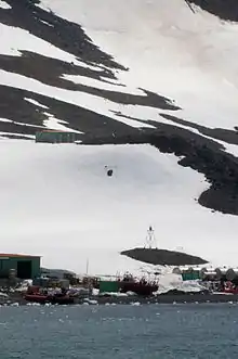 Martel Inlet Lighthouse located at Comandante Ferraz Antarctic Station | |
 Martel Inlet Antarctica | |

| |
| Location | Martel Inlet Comandante Ferraz Station King George Island Antarctica |
|---|---|
| Coordinates | 62°05′02″S 58°23′31″W |
| Year first constructed | 2007[1] |
| Foundation | concrete base |
| Construction | metal skeletal tower |
| Tower shape | square pyramidal skeletal tower with balcony and light |
| Markings / pattern | red and white tower, red lantern |
| Tower height | 4 metres (13 ft)[2] |
| Focal height | 14 metres (46 ft)[2] |
| Light source | solar power |
| Range | 10 nautical miles (19 km; 12 mi)[2] |
| Characteristic | Iso R 2s.[2] |
| Admiralty number | G1387.5[2] |
| NGA number | 2729[2] |
| Managing agent | Proantar[1] |
Visca Anchorage is the northwestern cove of Martel Inlet. It was named by Charcot for an acquaintance in Montevideo.[5] Within the cove is Sea Leopard Patch, a shoal with a least depth of 18 m (59 ft). It was charted in 1927 by Discovery Investigations personnel on the Discovery and named after the leopard seal, Hydrurga leptonyx.[6]
See also
References
- "Antarctica". The Lighthouse Directory. University of North Carolina at Chapel Hill. Retrieved 23 May 2017.
- List of Lights, Pub. 111: The West Coasts of North and South America (Excluding Continental U.S.A. and Hawaii), Australia, Tasmania, New Zealand, and the Islands of the North and South Pacific Oceans (PDF). List of Lights. United States National Geospatial-Intelligence Agency. 2017.
- "Martel Inlet". Geographic Names Information System. United States Geological Survey. Retrieved 2020-09-11.
- "Ullmann Spur". Geographic Names Information System. United States Geological Survey. Retrieved 2020-09-11.
- "Visca Anchorage". Geographic Names Information System. United States Geological Survey. Retrieved 2020-09-11.
- "Sea Leopard Patch". Geographic Names Information System. United States Geological Survey. Retrieved 2020-09-11.
![]() This article incorporates public domain material from the United States Geological Survey document: "Martel Inlet". (content from the Geographic Names Information System)
This article incorporates public domain material from the United States Geological Survey document: "Martel Inlet". (content from the Geographic Names Information System)