Maryland Route 237
Maryland Route 237 (MD 237) is a state highway in the U.S. state of Maryland. Known as Chancellors Run Road, the route runs 2.95 miles (4.75 km) from MD 246 near Lexington Park north to MD 235 in California. MD 237, which was designated in the mid-1980s, bypasses the center of Lexington Park through the suburban area surrounding Naval Air Station Patuxent River (NAS Patuxent River). The state highway was expanded to a four-lane divided highway between 2008 and 2010 in response to increased activity at the military base.
| ||||
|---|---|---|---|---|
| Chancellors Run Road | ||||
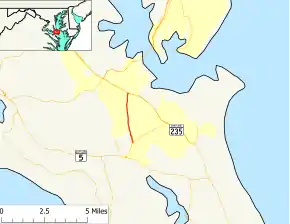 Maryland Route 237 highlighted in red | ||||
| Route information | ||||
| Maintained by MDSHA | ||||
| Length | 2.95 mi[1] (4.75 km) | |||
| Existed | 1987–present | |||
| Major junctions | ||||
| South end | ||||
| North end | ||||
| Location | ||||
| Counties | St. Mary's | |||
| Highway system | ||||
| ||||

Route description
_at_Pegg_Road_in_Great_Mills%252C_St._Mary's_County%252C_Maryland.jpg.webp)
MD 237 begins west of Lexington Park at an intersection with MD 246 (Great Mills Road), which heads east to NAS Patuxent River, near Great Mills High School. The state highway heads north as a four-lane road with a center left-turn lane between residential subdivisions. At Pegg Road, MD 237 becomes a four-lane divided highway. The state highway crosses Jarboesville Run in a forested area before continuing between residential subdivisions. MD 237 passes Chancellors Run Regional Park and crosses the Three Notch Trail before reaching its northern terminus at MD 235 (Three Notch Road) in California.[1][2]
History
The original MD 237 roughly followed what is today MD 234 between Chaptico and MD 5 near Leonardtown via Clements.[3] The modern MD 237 was designated along what had been county-maintained Chancellors Run Road around 1987.[4] By 2003, heavy traffic along MD 237 related to greater activity at NAS Patuxent River led to the highway being marked for expansion.[5] Between 2008 and 2010, MD 237 was expanded from a two-lane road to a four-lane divided highway from Pegg Road to MD 235. The speed limit on the road increased from 40 mph (64 km/h) to 45 mph (72 km/h) in 2015 [6]
Junction list
The entire route is in St. Mary's County.
| Location | mi[1] | km | Destinations | Notes | |
|---|---|---|---|---|---|
| Lexington Park | 0.00 | 0.00 | Southern terminus | ||
| California | 2.95 | 4.75 | Northern terminus | ||
| 1.000 mi = 1.609 km; 1.000 km = 0.621 mi | |||||
See also
 Maryland Roads portal
References
- Highway Information Services Division (December 31, 2013). Highway Location Reference. Maryland State Highway Administration. Retrieved 2012-08-10.
- St. Mary's County (PDF).
- Google (2010-11-04). "Maryland Route 237" (Map). Google Maps. Google. Retrieved 2010-11-04.
- Maryland State Roads Commission (1960). Maryland: Official Highway Map (Map). Baltimore: Maryland State Roads Commission.
- Maryland State Highway Administration (1987). Maryland: Official Highway Map (Map). Baltimore: Maryland State Highway Administration.
- McCaffrey, Raymond (March 16, 2003). "Hughesville Bypass Is Top Priority; State Seeking Federal Road, Transit Funding". The Washington Post. Washington, DC: The Washington Post Company. p. T01.
- "State Reaches Major Milestone In $38 Million Project To Improve Safety On MD 237". Maryland State Highway Administration. October 21, 2010. Retrieved 2010-11-04.