McElroy Creek
McElroy Creek is a tributary of Middle Island Creek, 22.1 miles (35.6 km) long,[5] in northern West Virginia in the United States. Via Middle Island Creek and the Ohio River, it is part of the watershed of the Mississippi River, draining an area of 106.2 square miles (275 km2)[6] in a rural region on the unglaciated portion of the Allegheny Plateau.
| McElroy Creek | |
|---|---|
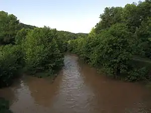 McElroy Creek in Shirley | |
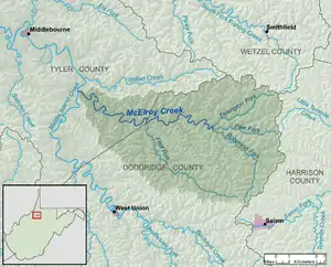 A map of McElroy Creek and its watershed | |
| Location | |
| Country | United States |
| State | West Virginia |
| Counties | Doddridge, Tyler |
| Physical characteristics | |
| Source | Robinson Fork |
| • location | Doddridge County, northwest of Salem |
| • coordinates | 39.3064755°N 80.5878753°W[1] |
| • length | 10 miles (16 km) |
| • elevation | 1,153 ft (351 m)[2] |
| 2nd source | Pike Fork |
| • location | Doddridge County, northeast of Sedalia |
| • coordinates | 39.3848083°N 80.5431503°W[3] |
| • length | 5.8 miles (9.3 km) |
| • elevation | 1,089 ft (332 m)[2] |
| Source confluence | |
| • location | Center Point, Doddridge County |
| • coordinates | 39.389251°N 80.6370432°W[4] |
| • elevation | 781 ft (238 m)[2] |
| Mouth | Middle Island Creek |
• location | southwest of Tyler, Tyler County |
• coordinates | 39.4300801°N 80.8317721°W[4] |
• elevation | 686 ft (209 m)[4] |
| Length | 22.1 mi (35.6 km) |
| Basin size | 106.2 sq mi (275 km2) |
| Basin features | |
| Tributaries | |
| • left | Flint Run |
| • right | Talkington Fork |
| Hydrologic Unit Code | 0503020103 (USGS) |
Geography
McElroy Creek is formed near the unincorporated community of Center Point in northern Doddridge County by the confluence of two streams:
- the Robinson Fork,[1] 10 miles (16 km) long,[5] which rises in Doddridge County approximately 2.3 miles (3.7 km) northwest of the city of Salem and flows northward and northwestward, through Sedalia
- the Pike Fork,[3] 5.8 miles (9.3 km) long,[5] which rises in Doddridge County approximately 2.6 miles (4.2 km) northeast of Sedalia and flows westward.
A short distance downstream of this confluence, it collects a third significant headwaters tributary, the Talkington Fork.
From Center Point, McElroy Creek flows generally westward into eastern Tyler County, through the unincorporated community of Ashley in Doddridge County and the unincorporated communities of Little Pittsburg and Shirley in Tyler County, collecting Flint Run, its largest tributary, on the boundary of Doddridge and Tyler Counties. It flows into Middle Island Creek from the east, a short distance southwest of the community of Tyler. The creek is paralleled by West Virginia Route 23 for most of its course.[7][8]
According to the Geographic Names Information System, the creek has also been known historically by the spelling "McElroys Creek."[4]
History
The "Three Forks of McElroy Creek" (near present Center Point) were first settled in 1812 by brothers Joshua Allen (1787-1867) and Israel Allen (1792-1853).[9] This was then in District 19 of Harrison (later Doddridge) County. The district was renamed McClellan District after the American Civil War.
References
- Geographic Names Information System. "Geographic Names Information System entry for Robinson Fork (Feature ID #1545868)". Retrieved 2013-07-17.
- The National Map elevation for GNIS source coordinates. Retrieved 2013-07-17.
- Geographic Names Information System. "Geographic Names Information System entry for Pike Fork (Feature ID #1544848)". Retrieved 2013-07-17.
- Geographic Names Information System. "Geographic Names Information System entry for McElroy Creek (Feature ID #1542995)". Retrieved 2013-07-17.
- United States Environmental Protection Agency. "West Virginia, Little Muskingum-Middle Island Watershed". Archived from the original on 2011-10-15. Retrieved 2013-07-17.
- U.S. Geological Survey. National Hydrography Dataset. Area data for McElroy Creek watershed, 10-digit Hydrologic Unit Code 0503020103. The National Map Archived 2012-04-05 at WebCite, retrieved 2013-07-17
- The National Map Archived 2012-04-05 at WebCite, accessed 2013-07-17
- West Virginia Atlas & Gazetteer. Yarmouth, Me.: DeLorme. 1997. p. 24. ISBN 0-89933-246-3.
- Hardesty's Historical and Geographical Encyclopedia, Vol. 2; Chicago, Illinois: H. H. Hardesty, 1883. (Reprinted, Richwood: Comstock, Hardesty West Virginia Counties, 8 vols., 1973.)