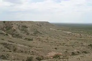
Mescalero Ridge
The Mescalero Ridge forms the western edge of the great Llano Estacado, a vast plateau or tableland in the southwestern United States in New Mexico and Texas.[2][3] It is the western equivalent of the Caprock Escarpment, which defines the eastern edge of the Llano Estacado.
| Mescalero Ridge | |
|---|---|
| (Mescalero Escarpment) | |
 | |
| Highest point | |
| Elevation | 4,462 ft (1,360 m) [1] |
| Prominence | 200 ft (61 m) |
| Coordinates | 33°02′35″N 103°51′13″W [1] |
| Geography | |
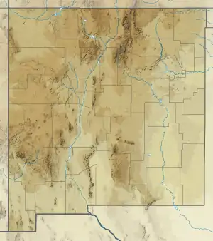 Mescalero Ridge Location in Eastern New Mexico | |
| Geology | |
| Age of rock | Quaternary |
| Mountain type | Caliche |
Mescalero Sands
Extending north-south along the western edge of the Mescalero Ridge lies a vast sand sheet called the Mescalero Sands, named after the Mescalero Apaches who once hunted in these sandhills.[4][5] In 1928, Nelson Horatio Darton of the United States Geological Survey observed: “On the east side of the Pecos Valley in southern New Mexico there are very extensive sand hills formed of deposits known as the ‘Mescalero Sands,’ which are doubtless of Quaternary age ...” [6] In places, these sands climb up and over the Mescalero Ridge and spread out over portions of the Llano Estacado.
References
- "Mescalero Ridge". Geographic Names Information System. United States Geological Survey.
- Price, A.P. 1977. Mescalero Sandhills of Cochran and Yoakum Counties, Texas. Master's thesis, Texas Tech University, Lubbock, 253 pp.
- Henderson, D. 2006. An Introduction to the Mescalero Sands Ecosystem. Master's thesis, Texas A&M University, 42 pp.
- Julyan, R. 1996. The Place Names of New Mexico. University of New Mexico Press, Albuquerque.
- Hall, S.A. 2002. Field Guide to the Geoarchaeology of the Mescalero Sands, Southeastern New Mexico. State of New Mexico Historic Preservation Division and New Mexico Bureau of Land Management, Project No. 35-00-15334.11, 59 pp.
- Darton, N.H. 1928. "Red Beds" and associated formations in New Mexico, with an outline of the geology of the state. United States Department of the Interior, U.S. Geological Survey, Bulletin 794, 356 pp. (Mescalero sands described on p. 59)
External links
- High Plains Historical Foundation
- U.S. Geological Survey Geographic Names Information System: Mescalero Ridge
- Public domain images of the Llano Estacado and Eastern New Mexico