Miners River
The Miners River is a river on the Upper Peninsula of Michigan in the United States. It is the largest river in the Pictured Rocks National Lakeshore. Miners River has its origin outside of the National Lakeshore, north of Indian Town in the Hiawatha National Forest, and flows 12.4 miles (20.0 km) into Lake Superior.[2] Miners Lake and Miners Falls are found along the river. The river empties into Lake Superior at the western end of Miners Beach. It is popular for tourism and fishing.
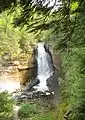 View of Miners Falls on Miners River
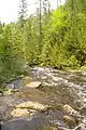 A view of Miners River below Miners Falls
 Miners River near the outlet to Lake Superior
| Miners River | |
|---|---|
 Mouth of Miners River at Miners Beach | |
| Location | |
| Country | United States |
| Physical characteristics | |
| Source | |
| • location | Alger County, Michigan |
| • coordinates | 46.4294°N 86.5763°W[1] |
| Mouth | |
• location | Lake Superior, Michigan |
• coordinates | 46.4952°N 86.5454°W |
| Length | 12.4 mi (20.0 km) |
See also
References
- "Miners River". Geographic Names Information System. United States Geological Survey.
- U.S. Geological Survey. National Hydrography Dataset high-resolution flowline data. The National Map Archived 2012-04-05 at WebCite, accessed January 3, 2012
| Wikimedia Commons has media related to Miners River. |
This article is issued from Wikipedia. The text is licensed under Creative Commons - Attribution - Sharealike. Additional terms may apply for the media files.