Minneapolis Skyway System
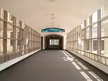
The Minneapolis Skyway System is an interlinked collection of enclosed pedestrian footbridges that connect various buildings in 80 full city blocks over 9.5 miles (15.3 km) of Downtown Minneapolis, enabling people to walk in climate-controlled comfort year-round.[1] The skyways are owned by individual buildings in Minneapolis, and as such they do not have uniform opening and closing times.[2] The 11 miles of skyway[2] are comparable to the Houston tunnel system, the systems in Canadian cities such as Toronto's PATH, Montreal's Underground City,[3] Calgary's 11-mile +15 system and the 8-mile Edmonton Pedway system.

The Minneapolis skyways connect the second or third floors of various office towers, hotels, banks, corporate and government offices, restaurants, and retail stores to the Nicollet Mall shopping district, the Mayo Clinic Square, and the sports facilities at Target Center, Target Field and U.S. Bank Stadium. Several condominium and apartment complexes are skyway-connected as well, allowing residents to live, work, and shop downtown without having to leave the skyway system.
History and development
The city's first skyways were planned by real estate developer Leslie Park in the early 1960s and built by Crown Iron Works Company of Minneapolis. Sensing pressure from indoor shopping malls such as Southdale Center, Park wanted to create a similar environment in Downtown Minneapolis that would offer a climate-controlled space and a way for pedestrians to move from building to building. He built two skyways connecting the newly constructed Northstar Center building to the Northwestern Bank Building and the Roanoke Building. The skyway to the Northwestern Bank Building was built in 1962 and the skyway to the Roanoke Building followed the next year. The second skyway still remains in use today and is the system's oldest segment.[4]
The system grew to seven total segments by 1972, though many of the skyways remained disconnected from one another. The construction of the IDS Center in 1974 helped to unify the system. The building featured skyways in all four directions as well as a spacious atrium area called the Crystal Court, allowing it to act as a central hub for the entire system. In 1976, the Downtown Council produced the first formal maps and signage for the system.[4][5]
In 2016, the U.S. Bank Stadium became connected to the Minneapolis skyway via a mixed-use development of office buildings and apartment complexes in Downtown East, Minneapolis.[6]
Notable buildings connected
- Butler Square
- IDS Center
- Foshay Tower
- U.S. Bank Stadium
- Target Center
- Mayo Clinic Square
- Minneapolis Convention Center
- University of St. Thomas
- Capella Tower
- Wells Fargo Center
- 33 South Sixth/Minneapolis City Center
- Campbell Mithun Tower
- Ameriprise Financial Center
- Hennepin County Government Center
- U.S. Bank Plaza
- RBC Plaza
- US Bancorp Center
- Fifth Street Towers
- AT&T Tower
- 100 Washington Square
- 510 Marquette Building
Guides
Various guides to navigation exist including paper and online maps as well as apps.
References
- "Your Guide to the Minneapolis Skyway System". Meet Minneapolis. Retrieved September 23, 2020.
- James, Clara. "Minneapolis Skyway System". About.com. Archived from the original on 5 November 2013. Retrieved 17 August 2013.
- Ralph Blumenthal, It’s Lonesome in This Old Town, Until You Go Underground Archived 2017-08-01 at the Wayback Machine, The New York Times, August 21, 2007,
- Nathanson, Iric. "Minneapolis' oldest skyway still in use turns 50". MinnPost. Archived from the original on 2016-02-01. Retrieved 2016-01-26.
- Jacob, Bernard; Morphew, Carol (1984). Skyway Topology Minneapolis: A Study of the Minneapolis Skyways. Washington DC: AIA Press. p. 25.
- Moore, Janet. "Wells Fargo to spend $300M to build 2 towers near Vikings stadium". Minneapolis StarTribune. Archived from the original on 2014-10-09. Retrieved 2014-07-08.
External links
- Downtown Minneapolis – Hotels and Skyways map of system, Minneapolis CVB 2016
- Downtown Minneapolis Skyway Guide interactive map. Skyway My Way, 2012.