Mississippi Highway 444
Mississippi Highway 444 (MS 444) is a short highway in western Mississippi. Its western terminus is at MS 1, and travels eastward through six miles (9.7 km) of farmland. The route enters Duncan, and ends at U.S. Route 61 (US 61) and US 278, its eastern terminus. MS 444 was designated in 1958, and became paved two years later.
| ||||
|---|---|---|---|---|
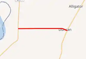
MS 444 highlighted in red | ||||
| Route information | ||||
| Maintained by MDOT | ||||
| Length | 6.578 mi[1] (10.586 km) | |||
| Existed | 1958–present | |||
| Major junctions | ||||
| West end | ||||
| East end | ||||
| Location | ||||
| Counties | Bolivar | |||
| Highway system | ||||
| ||||

Route description
All of the road is located in northern Bolivar County. In 2012, Mississippi Department of Transportation (MDOT) calculated as many as 750 vehicles traveling west of US 61/US 278, and as few as 330 vehicles traveling east of MS 1.[2] MS 444 is not included as a part of the National Highway System (NHS), a network of highways identified as being most important for the economy, mobility and defense of the nation.[3] MS 444 is legally defined in Mississippi Code § 65-3-3.[4] MS 444 is maintained by MDOT.[1]
MS 444 starts at a T-intersection with MS 1 and travels eastward. The route travels through farmland in a straight line. MS 444 intersects Caston Road, a dirt road that also leads to Duncan. MS 444 continues east, intersecting minor dirt roads. East of Yates Road, the road enters a small area of trees, before re-entering to more farmland. The route curves slightly to the southeast about one mile (1.6 km) later, at Sandy Ridge Road. MS 444 soon crosses the Hushpuckena River, and enters into Duncan. Near the center of Duncan, the route intersects the old alignment of US 61. The road continues east and ends at a T-intersection with US 61.[5]
History
MS 444 was designated in 1958, as an unpaved road from MS 1 to US 61.[6][7] The route became paved by 1960.[7][8] In 1967, US 61 was rerouted to its east, no longer passing through Duncan.[9][10] By 1999, US 278 was designated, concurrent with US 61 through MS 444's eastern terminus.[11][12]
Major intersections
The entire route is in Bolivar County.
| Location | mi[1] | km | Destinations | Notes | |
|---|---|---|---|---|---|
| | 0.000 | 0.000 | Western terminus | ||
| Duncan | 6.578 | 10.586 | Eastern terminus | ||
| 1.000 mi = 1.609 km; 1.000 km = 0.621 mi | |||||
See also
 Mississippi portal
 U.S. Roads portal
References
- Mississippi Department of Transportation Planning Division (December 31, 2011). Mississippi Public Roads Selected Statistics Extent, Travel, and Designation (PDF) (Report). Mississippi Department of Transportation. Archived from the original (PDF) on May 14, 2014. Retrieved April 29, 2014.
- "MDOT Traffic Count Application". Mississippi Department of Transportation. Retrieved May 6, 2014.
- National Highway System: Mississippi (PDF) (Map). Federal Highway Administration. November 2003. Retrieved July 7, 2014.
- "Mississippi Code Of 1972 As Amended - SEC. 65-3-3. State highways designated". Mississippi Legislature. Retrieved April 21, 2014.
- Microsoft; Nokia (July 7, 2014). "Mississippi Highway 444" (Map). Bing Maps. Microsoft. Retrieved July 7, 2014.
- Official Road Map of State of Mississippi (PDF) (Map). Cartography by Mississippi State Highway Commission. Mississippi State Highway Commission. 1958. Archived from the original (PDF) on May 14, 2014. Retrieved May 6, 2014.
- Official Road Map of State of Mississippi (PDF) (Map). Cartography by Mississippi State Highway Commission. Mississippi State Highway Commission. 1958. Archived from the original (PDF) on May 14, 2014. Retrieved May 6, 2014.
- Official Road Map of State of Mississippi (PDF) (Map). Cartography by Mississippi State Highway Commission. Mississippi State Highway Commission. 1960. Archived from the original (PDF) on April 19, 2014. Retrieved April 18, 2014.
- Official Road Map of State of Mississippi (PDF) (Map). Cartography by Mississippi State Highway Commission. Mississippi State Highway Commission. 1965. Archived from the original (PDF) on May 14, 2014. Retrieved July 8, 2014.
- Official Road Map of State of Mississippi (PDF) (Map). Cartography by Mississippi State Highway Commission. Mississippi State Highway Commission. 1967. Archived from the original (PDF) on May 14, 2014. Retrieved July 8, 2014.
- Official Highway Map of Mississippi (PDF) (Map). Cartography by Mississippi Department of Transportation. Mississippi Department of Transportation. 1998. Archived from the original (PDF) on May 14, 2014. Retrieved May 6, 2014.
- Official Highway Map of Mississippi (PDF) (Map). Cartography by Mississippi Department of Transportation. Mississippi Department of Transportation. 1999. Archived from the original (PDF) on May 14, 2014. Retrieved May 6, 2014.