Mississippi River Band of Chippewa Indians
Mississippi River Band of Chippewa Indians (Ojibwe: Gichi-ziibiwininiwag) or simply the Mississippi Chippewa, are a historical Ojibwa Band inhabiting the headwaters of the Mississippi River and its tributaries in present-day Minnesota.
According to the oral history of the Mississippi Chippewa, they were primarily of the southern branch of Ojibwe who spread from the "Fifth Stopping Place" of Baawiting (Sault Ste. Marie region) along Lake Superior's southern shores until arriving at the "Sixth Stopping Place" of the Saint Louis River. They continued westward across the Savanna Portage, and spread both northward and southward along the Mississippi River and its major tributaries.
Before entering the treaty process with the United States, the Mississippi Chippewa consisted of the following sub-bands:
- Cedar Lake Band
- Crow Wing Band
- Gull Lake Band
- Mille Lacs Band
- Pelican Lake Band
- Pokegama Lake Band
- Rabbit Lake Band
- Rice Lake Band
- Sandy Lake Band
- Snake River Band
- Swan River Band
- Trout Lake Band
- White Oak Point Band
and many villages associated with these sub-bands. Together, they controlled the main north-south trade corridor of the Mississippi River headwaters. Their traditional use area included the stretch of the Mississippi River between its confluence with the Leech Lake River and its confluence with the Crow Wing River—known in the Ojibwe language as Gichi-ziibi (Big River)—and including the Brainerd Lakes Area.
History and treaty making

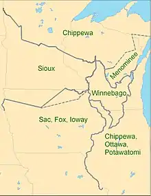
In 1825, with the First Treaty of Prairie du Chien, the United States drew the Prairie du Chien Line to separate the Ojibwe from the Dakota, believing the two were still at war with each other. The Ojibwe and the Dakota had ended their war for nearly a generation by that time and had only infrequent skirmishes.
The Mississippi Chippewa, along with the Red Lake, Pillager and the Lake Superior bands, entered into the Treaty of St. Peters in 1837 with the US. They ceded to the United States what is now part of northern Wisconsin and east-central Minnesota.
In 1850, the US government changed the annuity distribution point from La Pointe, Wisconsin to Sandy Lake, in an effort to move the tribes further west. Four thousand Ojibwe of various bands showed up in early October at the designated site, but no government agents or supplies were there. After waiting for two months in deteriorating weather, 170 Ojibwe died. The government finally brought the supplies and annuities but, because of harsh weather at that time of year, another 230 Ojibwe died on their returns to their lands.[1] This became known as the Sandy Lake tragedy.

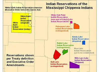
In 1855, because of the tragedy at Sandy Lake, the Mississippi Chippewa, along with the Pillager Band of Chippewa Indians, agreed upon the Treaty of Washington for the land cession of most of northern Minnesota. In exchange, the United States promised three reservations for the Pillagers and six reservations for the Mississippi Chippewa. In addition, as in other treaties, the tribes retained the right for traditional harvest of off-reservation resources, such as fish and game. (This right faded from general knowledge as living conditions changed, until it was revived in the late 20th century as tribes worked to exercise traditional practices and rights; one example was the Wisconsin Walleye War of the late 1980s.)
The six reservations were the following:
- Gull Lake Indian Reservation
- Mille Lac Indians Reservation
- Pokegama Lake Indian Reservation
- Sandy Lake Indian Reservation
- Rabbit Lake Indian Reservation
- Rice Lake Indian Reservation
Due to confusing records kept by the U.S. Bureau of Land Management, the Rice Lake Indian Reservation was never established. Confusion arose because several different lakes around Sandy Lake had names which, translated into English, all seemed to mean "Rice Lake." This led to confusion related to which map was consulted, and the issue of where the reservation was to be located was never resolved. It appeared the Rice Lake Indian Reservation was located in the following areas:
- fully within the boundaries of the Sandy Lake Indian Reservation on its north end, or
- adjacent to the Sandy Lake Indian Reservation on its south end; and
- at the southeastern corner on the eastern edge of Sandy Lake Indian Reservation, or
- on the southeastern corner on the southern edge of Sandy Lake Indian Reservation.
The Rice Lake Band claimed these representations were all incorrect, and the proper location of the agreed Rice Lake Indian Reservation was much farther south.
In the Dakota War of 1862, waged against European-American settlers, many Chippewa bands aided the Dakota people. The Sandy Lake Band remained fully neutral during the conflict. When Chief Máza-mani (Iron-Walker) (Mille Lacs Indians) learned of the plans of Chief Bagone-giizhig (Hole-in-the-Day) (Gull Lake Band) to attack Fort Ripley, Máza-mani raised a party of 200 men to aid the Americans. They reached the fort and aided in its defense before Chief Bagone-giizhig arrived, thus averting his attack. Both the Sandy Lake and Mille Lacs bands gained protection from the United States as a result.
All other Mississippi Chippewa were forcibly removed from their reservations to the area surrounding the Leech Lake and Lake Winnibigoshish reservations. Due to strife between the removed Mississippi Chippewa and the Leech Lake Pillager and the Lake Winnibigoshish bands, the Mississippi Chippewa negotiated with the United States for resettlement. The Pokegama Lake Band, together with the few Removable Sandy Lake Band, negotiated to remain in the area and eventually formed the White Oak Point Band on the White Oak Point Reservation. In 1934 it merged with the Cass Lake, Chippewa, Lake Winnibigoshish and Leech Lake Indian reservations to form the contemporary Leech Lake Band of Ojibwe and its reservation.
With the signing of the 1867 Treaty of Washington, the remaining Mississippi Chippewa about Leech Lake agreed to resettlement to the west, creating the White Earth Reservation. In the 20th century, the bands combined to form the contemporary White Earth Band of Chippewa. Under pressure from the lumbermen and farm settlers who wanted native lands, the US government believed the White Earth Reservation was the answer to the "Chippewa Problem" and strongly pressured the Mille Lacs and the remaining Sandy Lake bands to relocate there. Many did, becoming the "Removable" peoples, while those who remained in their traditional territories in the central part of the state became the "Non-removable".
Successors apparent
Though the Mississippi River Band of Chippewa Indians no longer exists legally, the majority of the Mille Lacs Band of Ojibwe and White Earth Band of Chippewa still identify as Mississippi Chippewa. Successors apparent of the Mississippi Chippewa are:
References
- "Ojibwe honor 400 victims of 1850 Sandy Lake tragedy" Archived 2013-06-19 at the Wayback Machine, Brainerd Dispatch, 2 December 2000, accessed 8 March 2012
- Warren, William W. History of the Ojibway People. Borealis Books (St. Paul, MN: 1984).
- Wedll, Joycelyn. Against the Tide of American History: The Story of Mille Lacs Anishinabe. Minnesota Chippewa Tribe (Cass Lake, MN: 1985).
External links
- "Ojibwe leaders represent their credentials to Washington in a picture" (birch bark picture, 1849, for renegotiation of 1842 treaty), Wisconsin History
- "Ojibwe honor 400 victims of 1850 Sandy Lake tragedy", Brainerd Dispatch, 2 December 2000
- "The Sandy Lake memorial monument takes shape 150 years after tragedy", Winter 2000