Miyako, Fukuoka
Miyako (みやこ町, Miyako-machi) is a town located in Miyako District, Fukuoka Prefecture, Japan.
Miyako
みやこ町 | |
|---|---|
Town | |
 Flag  Chapter | |
 Location of Miyako in Fukuoka Prefecture | |
 Miyako Location in Japan | |
| Coordinates: 33°42′N 130°55′E | |
| Country | Japan |
| Region | Kyushu |
| Prefecture | Fukuoka Prefecture |
| District | Miyako |
| Area | |
| • Total | 151.28 km2 (58.41 sq mi) |
| Population (April 30, 2017) | |
| • Total | 20,286 |
| • Density | 130/km2 (350/sq mi) |
| Time zone | UTC+09:00 (JST) |
| Website | www |
Miyako formed by a merger of the towns of Katsuyama 勝山, Saigawa 犀川 and Toyotsu 豊津, all from the Miyako District. It was officially founded on March 20, 2006.
Last recorded on April 30, 2017, the town had an estimated population of 20,286.[1] The total area size of the town is 151.28 km²
Saigawa
The Saigawa District is surrounded by mountains and Fukuoka Prefectural Road 34 and the Heisei Chikuho railway run east and west through it. The two rivers, Imagawa and Haraigawa flow through the district. The Shinto God, Sai no Kami was enshrined at a crossing place along the Imagawa river. The name of the town is based on its history and was created by combining ‘Sai’ from ‘Sai no Kami’ and ‘gawa’ from ‘kawa’ or ‘river’.
History
In 1905, East Saigawa Village, West Saigawa Village, and Minami Saigawa Village merged to form the Saigawa Village. In 1943, it was renamed Saigawa Town and expanded to include the Irahara Village in 1956. In 2006, Saigawa Town merged with Katsuyama and Toyotsu to become Miyako.
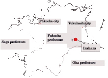
Irahara
Irahara is located in Miyako Town south of Yukuhashi, Fukuoka and is surrounded by natural features. It is located along Route 496 at 33°42'N, 130°55'E and is 253 m above sea level. The town has an area of 2, 356 km2 and a population of 284.
History
People were first identified to be living in Irahara approximately 3000 years ago during the Jōmon period. in 2017, most of the town was submerged in water following the construction of the Irahara Dam.
Landmark Architecture
The Naganuma House is a historical building that was constructed in1839. It represents the lifestyle in the Edo era.
Wildlife
The Miyako Sawa-Gani is an endangered freshwater crab that is native to Miyako Island. The species cannot survive in sea water and live in habitats that are confined to inland waters or land.
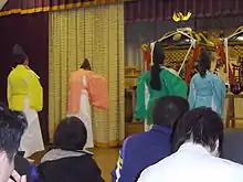
Kagura
Kagura is a traditional Noh dance common in Irahara. It is offered to the Gods of Shinto. The actions represent the stories of Japanese myths. The dance has been passed down from parents to children for generations.
Irahara Dam
Miyako Town experiences frequent flooding. In 2017, the multipurpose Dam called the Irahara Dam was constructed to prevent floods and contain tap water.
Harai River
The Harai River is 31km long and flows from Irahara to Yukuhashi City. Fireflies are common around the river in early summer.
Festivals
Many festivals are held throughout the year and are mainly concerned with agriculture. Jinkosai is a festival held in May where Kagura is common.
Food
Traditional foods include Hawasabi and rice.
Climate
The climate in Miyako is warm and temperate. Miyako has high annual rainfall at 1282 mm | 50.5 inch. The average annual temperature in the town is 10.9 °C | 51.6 °F.
References
- "Official website of Miyako Town" (in Japanese). Japan: Miyako Town. Retrieved 22 May 2017.
Miyako, I. (2020). Miyako climate: Average Temperature, weather by month, Miyako water temperature - Climate-Data.org. Retrieved 28 October 2020, from https://en.climate-data.org/asia/japan/iwate/miyako-5144/
External links
 Media related to Miyako, Fukuoka at Wikimedia Commons
- Miyako official website (in Japanese)
| Authority control |
|---|