Mohnenfluh
The Mohnenfluh is a 2,544-metre-high mountain in the Austrian state of Vorarlberg.
| Mohnenfluh | |
|---|---|
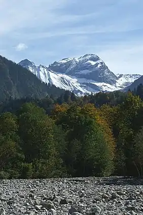 Mohnenfluh, view over the Bregenzer Ach | |
| Highest point | |
| Elevation | 2,544 m (AA) (8,346 ft) |
| Prominence | 385 m ↓ southwestern Butzensee |
| Isolation | 2.13 km → Butzenspitze |
| Coordinates | 47°13′57″N 10°6′9″E |
| Geography | |
 Mohnenfluh | |
| Parent range | Lechquellen Mountains |
The Mohnenfluh is the second-highest summit in the region of Schröcken after the Braunarlspitze, and is in the Lechquellen Mountains. An ascent is usually made via the Mohnen Saddle (2,315 m) and the south arête. The Bregenzer Ach rises on the eastern flank of the Mohnenfluh above Schröcken at a height of about 2,400 metres.
The name "Mohn(-en)" may be connected to the word Mond ("moon").[1] Because there are also mountain meadows or Bergmähder nearby, it may be derived from "Mahd" / "Mähen" ("meadow").
References
- Josef Zösmair, Die Bergnamen Vorarlbergs, UT: möglichst auf urkundlicher Grundlage erklärt, Verlag der Vorarlberger Buchdruckerei-Gesellschaft m.b.H., Dornbirn 1923, p. 28.
External links
| Wikimedia Commons has media related to Mohnenfluh. |
This article is issued from Wikipedia. The text is licensed under Creative Commons - Attribution - Sharealike. Additional terms may apply for the media files.