Molototsi River
The Molototsi River[1] is a non-perennial river that runs amongst villages in Bolobedu, South Africa. This river ascends from a village called Bodupe. Its stream flows to the Modjadji Dam in Ga-Matswi. It flows down to join the Great Letaba River near the Kruger National Park. Molototsi is one of the sandy rivers in Limpopo Province.
| Molototsi River | |
|---|---|
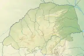 Location of the Molototsi's mouth | |
| Location | |
| Country | South Africa |
| Region | Limpopo |
| Physical characteristics | |
| Source | Modjadjiskloof |
| Mouth | Groot-Letaba River |
• coordinates | 23.67581°S 30.92138°E |
| Length | 120 km (75 mi) |
| Basin size | 1,170 km2 (452 sq mi) |

Activities
There are many farms surrounding it's valleys. These farming activities are mostly growing vegetables like tomatoes, pumpkins, peppers and potatoes. During the dry months, youth around Bolobedu organize beach football near Skhiming village where the river is open and extremely sandy. The river is also visited by an offroad club of enthusiasts who drive their 4x4 vehicles along the riverbed from Mageva village to Mokwakwaila village.[2][3]
References
- Molototsi at Geonames.org (cc-by); database downloaded on 2017-02-28
- Pajero Owners Club of South Africa ‐ Molototsi River Trip 8 August 2012
- Molototsi River 4x4 recreational activities at http://www.flickr.com
- Molototsi River and biomonitoring site no Mo3
- SABC News - Molototsi River (archive error: "No Content Available")