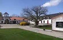
Mont-Saint-Jean, Belgium
Mont-Saint-Jean is a hamlet located in the province of Walloon Brabant, Belgium, south of Waterloo located partly on Waterloo and partly on Braine-l'Alleud where the National road (N5) going from Brussels to Charleroi crosses the National road (N234) going from Nivelles to Leuven.

.jpg.webp)
History
Mont-Saint-Jean is on the reverse slope of the escarpment where the Battle of Waterloo was fought, and is the name Napoleon Bonaparte gave to the battle (la bataille de Mont-Saint-Jean).[1] At the time of the battle there was a farm called Mont-Saint-Jean Farm, on the Charleroi–Brussels road about halfway between the edge of the escarpment and the village.[2]
Les Miserables
In the novel Les Miserables by Victor Hugo, Volume II, Book I, Chapter X is called "The Plateau of Mont-Saint-Jean" and it describes the massive French cavalry attacks on the British infantry squares situated on the reverse slope of the escarpment at the height of the battle.[3]
Notes
- Bonaparte 1820.
- Kaart van Ferraris 1777 section #78 'Braine la Leud' (in the south east corner)
- Hugo, Chapter X: The Plateau of Mont-Saint-Jean.
References
- Bonaparte, Napoleon (1820), Mémoires pour servir à l'histoire de France en 1815, avec le plan de la bataille de Mont-Saint-Jean
- "'Braine la Leud' #78", Kabinetskaart der Oostenrijkse Nederlanden et het Prinsbisdom Luik, Kaart van Ferraris, 1777
- Hugo, Victor, "Chapter X: The Plateau of Mont-Saint-Jean", Les Miserables