Monte Birrone
The Monte Birrone is a 2,131-metre (6,991 ft) high mountain in the Cottian Alps, belonging to the Italian province of Cuneo.
| Monte Birrone | |
|---|---|
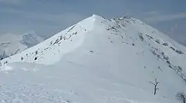 Winter view | |
| Highest point | |
| Elevation | 2,131 m (6,991 ft) [1] |
| Listing | Alpine mountains 2000-2499 m |
| Coordinates | 44°32′32″N 7°15′07″E |
| Geography | |
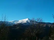
 Monte Birrone Location in the Alps | |
| Location | Piedmont, Italy |
| Parent range | Cottian Alps |
| Climbing | |
| Easiest route | hiking |
Geography
The mountain stands on the long ridge which, starting from the Main chain of the Alps, divides Maira Valley from Varaita Valley. It rises between two well defined mountain passes, Colle di Birrone (West of the summit, at 1,700 m) and Colle di Melle (1,871 m, East of it).[2] Close to the Monte Birrone passes an old military road built in order to deserve several military emplacements. It's open to cars and motorbikes during summertime. Administratively the mountain is divided between the comunes of Frassino and Sampeyre (Varaita Valley) and San Damiano Macra (Maira Valley).
SOIUSA classification
According to SOIUSA (International Standardized Mountain Subdivision of the Alps) the mountain can be classified in the following way:[3]
- main part = Western Alps
- major sector = North Western Alps
- section = Cottian Alps
- subsection = Southern Cottian Alps ((in Italian) Alpi del Monviso)
- supergroup = Gruppo del Chambeyron in a broad sense
- group = Gruppo della Marchisa
- subgroup = Costiera del Pelvo d'Elva
- code = I/A-4.I-A.4.d
Geology
From a geologic point of view, the mountain is made of ancient metamorphic rocks (pre-hercinic and hercinic) belonging to the Dora-Maira complex. W of the summit, near the colle Birrone, this kind of rocks border with schists ophiolitipher of the complex named Pietre verdi di Gastaldi (literally Green stones of Gastaldi.[4]
Access to the summit
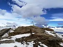
The summit of the Monte Birrone is easy to reach, and the normal route starts from the old military road which run close to the Maira/Varaita water divide.[2] It's marked by a summit cross. It also can be attained by mountain bike, carrying the bike in the last part of the ascent.[5] Besides summer hiking the Monte Birrone is also a popular winter destination for ski mountaineering and snowshoes hikes.[6]
References
- AA.VV. (1961). Piemonte (eccetto Torino e Valle d'Aosta). Touring club italiano - Officine grafiche A. Vallardi. p. 352. Retrieved 2020-08-03.
- Ferreri, Eugenio (1982). "404. Monte Birrone". Alpi Cozie centrali. Guida dei Monti d'Italia (in Italian). Milano: CAI / TCI. p. 278.
- Marazzi, Sergio (2005). Atlante Orografico delle Alpi. SOIUSA (in Italian). Priuli & Verlucca. ISBN 978-88-8068-273-8.
- Carta geologica d'Italia - foglio 78-79 - Argentera-Dronero Archived 2012-03-14 at the Wayback Machine
- "Monte Birrone" (in Italian). Mountain bike magazine. Retrieved 2020-07-30.
- cadri (2013-01-04). "Monte Birrone con le racchette da neve" (in Italian). lafiocavenmola.it. Retrieved 2020-07-30.
Maps
- Italian official cartography (Istituto Geografico Militare - IGM); on-line version: www.pcn.minambiente.it
- Istituto Geografico Centrale - Carta dei sentieri e dei rifugi scala 1:50.000 n. 7 Valli Maira, Grana e Stura
External links
 Media related to Monte Birrone at Wikimedia Commons
- Monte Birrone: ascent description on finoincima.altervista.org