Monte Politri
Monte Politri or Bric Rosso[3] is a 3,026 m a.s.l. mountain of the Cottian Alps, located in Italy.
| Monte Politri | |
|---|---|
| Bric Rosso | |
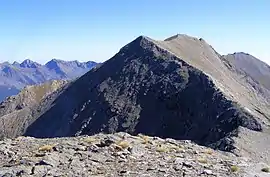 The mountain as seen from Fea Nera | |
| Highest point | |
| Elevation | 3,026 m (9,928 ft) [1] |
| Prominence | 313 m (1,027 ft) [2][1] |
| Parent peak | Monte Albergian |
| Listing | Alpine mountains above 3000 m |
| Coordinates | 44°59′28.28″N 07°01′7.36″E |
| Geography | |
 Monte Politri Alps | |
| Location | Piedmont, Italy |
| Parent range | Cottian Alps |
| Climbing | |
| Easiest route | Scrambling |
Geography
The mountain is located on the ridge between Val Chisone (North) and Valle Germanasca (South). Going West an unnamed saddle at 2863 divides Monte Politri from Fea Nera (2,946 m a.s.l.), while going East another saddle at 2,880 m separates it from Truc Cialabrie (2,936 m a.s.l.).[1]
Administratively the north face of the mountain belongs to the Fenestrelle municipality (comune) and the South one to Massello municipality,[1] both in the Metropolitan City of Turin. In clear days its summit offers a good view of Western Alps, a little limited towards NW by the neighbouring Monte Albergian.
SOIUSA classification
According to SOIUSA (International Standardized Mountain Subdivision of the Alps) the mountain can be classified in the following way:[4]
- main part = Western Alps
- major sector = North Western Alps
- section = Cottian Alps
- subsection = Alpi del Monginevro
- supergroup = Catena Bucie-Grand Queyron-Orsiera
- group = Gruppo Queyron-Albergian-Sestrière
- subgroup = Sottogruppo Ghinivert-Albergian
- code = I/A-4.II-A.2.b
Access to the summit
The usual route to Monte Politri starts from Colle dell'Albergian (2,713 m), which can be reached by waymarked footpath starting either from Balsiglia (Valle Germanasca) or from Laux (Val Chisone. While long from both these starting points, the route does not require alpine skills[3] but just scrambling. In the Italian scale of hiking difficulty is rated EE (Escursionisti Esperti, namely suitable for expert hikers).[5] Several climbing routes were described around the mountain, ranging from PD- to D+ grade.[3]
References
| Wikimedia Commons has media related to Bric Rosso. |
- "Geoportale Nazionale - carta IGM 1:25.000". Istituto Geografico Militare. Retrieved 2017-02-22.
- Key col: Colle dell'Albergian, 2713 m
- Ferreri, Eugenio (1982). Alpi Cozie cenrali. C.A.I./T.C.I. pp. 244–246.
- Marazzi, Sergio (2005). Atlante Orografico delle Alpi. SOIUSA (in Italian). Priuli & Verlucca. ISBN 978-88-8068-273-8.
- user Andrea81 (2009-04-22). "Politri (Monte) o Bric Rosso e Fea Nera da Balsiglia per il vallone del Pis". Retrieved 2017-02-22.
Maps
- Istituto Geografico Militare (IGM) official maps of Italy, 1:25.000 and 1:100.000 scale, on-line version
- Istituto Geografico Centrale - Carta dei sentieri e dei rifugi scala 1:50.000 n. 1 Valli di Susa Chisone e Germanasca