Morena
Morena is the headquarter city of Morena district, in the Indian state of Madhya Pradesh. It is governed by a municipality corporation. It is also the administrative headquarters of the Chambal division. It is 39 kilometres (24 mi) from Gwalior, Madhya Pradesh. Morena was once known for being terrorized by a large number of dacoits years ago. Morena is known as an industrial hub but the economy relies majorly on agriculture. Many manufacturing industries are situated in the industrial areas of Morena and Morena District.
Morena
Muraina | |
|---|---|
City | |
 | |
| Nickname(s): Mayurvan | |
 Morena Location in Madhya Pradesh  Morena Morena (India) | |
| Coordinates: 26.5°N 78.0°E | |
| Country | |
| State | Madhya Pradesh |
| District | Morena |
| Government | |
| • MP | Narendra Singh Tomar |
| Area | |
| • Total | 80 km2 (30 sq mi) |
| Elevation | 177 m (581 ft) |
| Population (2011)[1] | |
| • Total | 200,483 |
| • Rank | 154 |
| • Density | 2,500/km2 (6,500/sq mi) |
| Languages | |
| • Official | Hindi |
| Time zone | UTC+5:30 (IST) |
| PIN | 476001 |
| Telephone code | 07532 |
| Vehicle registration | MP-06 |
| Website | www |
Geography
Morena is located at 26.5°N 78.0°E.[2] It has an average elevation of 177 metres (580 feet).
It is connected by rail and national highway with Gwalior and Agra. Oilseed milling and cotton weaving are among the chief industries. The city has three colleges affiliated with Jiwaji University and two colleges affiliated with RGPV University.
The surrounding region was formerly occupied by the princely states of Sheopur, Sabalgarh, Gauraiya Basai, Gurjar Ghar and Esha. The lower Chambal River basin consists of an alluvial tract in the north, cut by numerous ravines, and a forested area toward the south. Wheat and oilseeds are the main crops, and building stone is quarried. Morena is known for its peacocks (150,959 in 2001). In ancient times, the area was called Mayur Van as it had a large amount of peacocks.
Demographics
As of 2011 census, Morena had a population of 288,303.[3] 13.2% of the population is under six years old.[3] Literacy was 80.28%; male literacy was 89.08% and female literacy was 70.22%.[3]
Notable people
- Ram Prasad Bismil, Indian revolutionary from the village of Barbai
- Narendra Singh Tomar, Minister in Indian government
- Rustam Singh, former minister in Madhya Pradesh government
- Ashok Argal, Mayor of Morena Municipal corporation.
- Paan Singh Tomar, athlete.
Places of interest
National Chambal Sanctuary, also called the National Chambal Gharial Wildlife Sanctuary, is a 5,400 km2 (2,100 sq mi) tri-state protected area in northern India for the critically endangered gharial (small crocodiles), the red-crowned roof turtle, and the endangered Ganges River dolphin. Located on the Chambal River near the tripoint of Rajasthan, Madhya Pradesh and Uttar Pradesh, the sanctuary was first declared in Madhya Pradesh in 1978 and now constitutes a long narrow eco-reserve co-administered by the three states. Within the sanctuary the pristine Chambal River cuts through mazes of ravines and hills with many sandy beaches.
The Pahargarh cave paintings are more than 30,000 years old on rocks of the Ashan River. They are 15 km from Fort Pahargarh. The Pahargarh was a zamindari seat of the Sikarwar Rajput clan under King Gurjar of Gauraiya Basai state.
Sas-Bahu Abhilekh reflects that Suhoniya, known as Sihoniya today, was the capital of the Kushwahas. The Kachwaha kingdom was established in the 11th century between 1015 and 1035 A.D. The Kachwaha king, Kirtiraj, had a Shiv temple erected at Sihoniya. This temple is known as the "Kakanmath" and was built without using any adhesive materials. It stands on a spot 2 miles (3 km) away from Sihoniya in northwestern Morena district. It is said that Kakan Math was built by King Kirtiraj to fulfill the will of Queen Kakanwati. It is 115 feet (35 m) high and is built in the Kajurho style.
Sihoniya is a holy place for practitioners of Jainism. In the east of the village are ruins from Jain temples dating from the 11th century A.D. In these temples there are statues of the Tirthankars such as Shantinath, Kunthnath, Arahanath, Adinath, Parshvnath and others. The main temple has three statues: Shantinath, Kunthnath, and Arhanath, each 10 to 15 feet (3.0 to 4.6 m) in height.
Kuntalpur, known as Kutwar, is the largest ancient village in the Chambal valley. It is just like Hastinapur, Rajgraha and Chadi of the Mahabharat period. The ancient Amba or Harrisiddhi Devi temple and a crescent-shaped dam erected on the river Asan are tourist spots in Kutwar. The Kotwal Reservoir is also a place for migratory birdwatching. There is also boating and fishing in this river. There is also an ancient village that is considered a Mahabharata-era village. One legend states that a character of Mahabharata Karna’s birthplace is in this village. Many ruins present there that look like a castle and many muddy pots, coins, utensils can be found.
Padawali
.JPG.webp)
The Gurjara-Pratiharas built several temples, scattered across the Padawali area, known as Bateshwar temples.
Around Padawali there are the ruins of several temples, houses and colonies. This new area of population is known as Padawali because it is surrounded by several hills. Here was a magnificent ancient Vishnu temple which was later converted into a large 'Garhi'. The terrace, the courtyard and the assembly hall of this temple are the epitome of ancient culture. The standing statue of a lion on the ruined gate seems to say that there was a time when he used to watch the temple with his companion at its gate. More than fifty monuments of different kinds can be seen at Padawali up to the valley of Bhuteshwar.
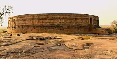
Mitawali
In the north of Naresar, there is a 64-yogini temple situated on a hundred foot high mountain. It is a circular construction of 170 feet (52 m) radius in the style of Delhi's Parliament House. Attached to the circular verandah are 64 rooms and a large courtyard in the temple. In the centre of the temple there is the circular temple of Lord Shiva and Lord Anuranjan. It was built by Gurjar Pratihar kings.

Amongst the monuments of the medieval age, the fort of Sabalgarh is worth visiting. A 'Bandh' was built behind the fort in the Scindia period. The foundation of Sabalgarh was laid by a 'Gujar' named Sabla in the past. Construction of the fort on a somewhat high cliff was made by Gopal Singh, the Raja of Karoli. Sikandar Lodhi sent an army to hold control over this strongly built fort. The Marathas, in their campaign of northern India, again won it and gave it back to the king of Karoli. But in the year 1795 it was again taken from him by Khande Rao, whose house still stands here. Lord Vallejali Daulat Rao Scindia (1764–1837) lived in the Fort of Gwalior during his regime. It was seized by the English in the year 1804–5. In 1809 the area around this fort was added to the kingdom of Scindia.[4]
Local cuisine
Gajak is a well-known sweet originating in Morena. It is made of sesame and jaggery specially manufactured during the winter. Another notable dessert or sweet from the Morena (Tanwarghar) region is malpuaa, which is made with jaggery and flour.
- Bedai-Sabji or Dahi-Jalebi
This special breakfast, usually served at street stands, consists of two parts: one spicy and one sweet. The bedai (sometimes spelled berahi) is a fried, puffy bread, much like kachori, served with a bowl of spicy green sabzi dotted with hunks of potato and a dollop of curd. The jalebi, which is often served in Delhi, is a sticky-sweet dessert made of fermented batter that's fried into ropy whorls, then soaked in hot sugary syrup. Freshly made and consumed one after another on a crowded street corner, together they make up the definitive balanced breakfast of Morena.
Schools
Schools in the district include:
- KIDZ A First Step Pre-Primary School.[5]
- Emmanuel Mission High School.
- Victor Convent H.S School.
- Saraswati Shishu Mandir.
- Neil World School.[6]
- Kendriya Vidyalaya Morena.
- Govt. Excellence School Morena.
- Ganga Public school.
- T.S.S. International School.
- The Biharee Convent High School.
- J. S. Public Higher Secondary School.
- J. S. Public School (Day boarding).[7]
- SRDM Public School.
- Saint Mary's School.
- Government MLB Girls Higher Secondary School.
- T.R. Gandhi Public School.
- TSS International School.
- Gov. G.D JAIN Higher Secondary School.
- The Learning Tree Pree School.
- City Montessory H.S school.
- Shri Dayal Convent School.
- R. K. Memorial Higher Secondary School.
- Krishna Convent School .
- Mother Teresa Convent H.S. School.
- Gyanoday High Secondary School.
- S.D.M Public School.
- Glorious public school
- Little Angel Convent High School
Transport
Road
Morena is situated on National Highway 3. The roadway connects all the parts of the state and nearby states such as Rajasthan and Uttar Pradesh. The city is situated at the heart of India and can be reached from anywhere in the country through National Highway No. 3. The city has Mofussil (city-to-city) bus services with connections to nearby towns, villages and cities. Buses and railways from Morena connect to cities such as Agra, New Delhi, Gwalior, Indore, Mumbai, and Bhopal.
Indian Railways
Morena railway station is well connected by trains services to all parts of the country including Delhi, Mumbai, Hyderabad, Chennai, Pune, Jaipur, Indore and other major cities. Direct connections by train are available to these cities. Express trains such as the Bhopal Express, Taj Express and Bhopal Shatabdi and many more stop at Morena. Morena is located in between the Delhi-Bhopal Railway route; by train from Morena it takes four hours to reach Delhi and six hours to reach Bhopal. Morena railway station is classified under 80 A class stations across India.
See also
References
- "Census of India Search details". censusindia.gov.in. Retrieved 10 May 2015.
- "Maps, Weather, and Airports for Morena, India".
- "Provisional Population Totals, Census of India 2011; Cities having population 1 lakh and above" (PDF). Office of the Registrar General & Census Commissioner, India. Retrieved 26 March 2012.
- https://www.youtube.com/watch?v=JDGVvXrLWUw&t=523s
- "KIDZ A First Step Pri-Primary School".
- "Neill World School".
- "J.S. PUBLIC SCHOOL – J.S. PUBLIC SCHOOL".