Morros de Macaira Natural Monument
The Morros de Macaira Natural Monument[1] (Spanish: Monumento Natural Morros de Macaira)[2] Is a protected area with status of natural monument located to the north of Guárico State, part of the South American country of Venezuela.[3][4] It was created in 1978. It covers an area of 99 ha. Throughout the region, it is common to find limestone rock masses, caves grooved with small water courses and deep vertical tops.
| Morros de Macaira Natural Monument Monumento Natural Morros de Macaira | |
|---|---|
IUCN category III (natural monument or feature) | |
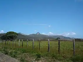 | |
.jpg.webp) Location | |
| Location | Venezuela |
| Coordinates | 9°52′N 66°38′W |
| Area | 0.99 km2 (0.38 sq mi) |
| Established | December 12, 1978 |
The Morros de Macaira Natural Monument is located in the municipality of José Tadeo Monagas. The western boundary of the monument is determined by the road that connects Altagracia de Orituco with San Francisco de Macaira.
Its main attraction is the calcareous formation of great paleontological and environmental value. It is constituted by three massifs, which lodge numerous caves crossed by fluvial torrents.
The vegetation is composed mainly of semideciduous forests and semideciduous thickets in the montane forest region of the mountain range of the coast of Venezuela.
References
- Monumento Natural Morros de Macaira
- IUCN Directory of Neotropical Protected Areas. IUCN. January 1, 1982. p. 409. ISBN 9780907567622.
Monumento Natural Morros de Macaira.
- Guía ecoturística de Venezuela (in Spanish). Miro Popić Editor C.A. January 1, 1998.
- Bauman, Janice; Young, Leni (January 1, 1987). Guide to Venezuela. E. Armitano, editor. ISBN 9789802160228.