Moses Lake
Moses Lake is a lake and reservoir along the course of Crab Creek, in Washington state, USA.
| Moses Lake | |
|---|---|
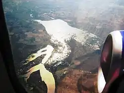
 Aerial view from the north (2009). Moses Lake is at lower left and the Potholes Reservoir at center. | |
 Moses Lake  Moses Lake | |
| Location | Grant County, Washington |
| Coordinates | 47.0809°N 119.3254°W |
| Type | natural lake, reservoir |
| Primary inflows |
|
| Primary outflows | Potholes Reservoir (to Lower Crab Creek) |
| Basin countries | United States |
| Surface area | 6,800 acres (28 km2) |
| Average depth | 18 ft (5.5 m) |
| Max. depth | 38 ft (12 m) |
| Surface elevation | 1,046 ft (319 m) |
| References | [1] |
Moses Lake is part of the Columbia River basin, as Crab Creek is a tributary of the Columbia River.
Although originally a shallow natural lake, Moses Lake was dammed in the early 20th century for irrigation purposes. It then became part of the Columbia Basin Project, built and managed by the United States Bureau of Reclamation. Moses Lake receives water from Crab Creek, as well as from irrigated agricultural runoff. Its water used to flow out into Crab Creek, but now flows into Potholes Reservoir, a storage reservoir created by impounding Crab Creek at O'Sullivan Dam.
Moses Lake is fairly complex in shape, with several arms, called "horns". These horns include Lewis Horn, Parker Horn, and Pelican Horn. There are several islands in Moses Lake, including Crest Island, Marsh Island, Gaileys Island, and Goat Island.
Moses Lake was named after Chief Moses in the late 19th century.[2] The city of Moses Lake was, in turn, named after the lake.[3]
The city of Moses Lake was first named Neppel, and not Moses Lake until 1938.
References
| Wikimedia Commons has media related to Moses Lake, Washington. |
- Christopher S. Magirl; Stephen E. Cox; Mark C. Mastin & Raegan L. Huffman (2010). "Sediment Loading from Crab Creek and Other Sources to Moses Lake, Washington, 2007 and 2008" (PDF). United States Geological Survey. Retrieved June 14, 2011.
- Meany, Edmond S. (1923). Origin of Washington geographic names. Seattle: University of Washington Press. p. 172.
- U.S. Geological Survey Geographic Names Information System: Moses Lake, USGS, GNIS