Moulouya River
The Moulouya River (Berber: iɣẓer en Melwect, Arabic: وادي ملوية) is a 520 km-long river in Morocco. Its sources are located in the Ayashi mountain in the Middle Atlas.[2] It empties into the Mediterranean Sea near Saïdia, in northeast Morocco at about 35.1228°N 2.3367°W.
| Moulouya River | |
|---|---|
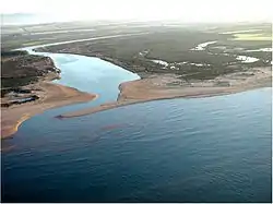 View of the mouth of the Moulouya | |
 | |
| Native name | Iɣẓer en Melwect وادي ملوية |
| Location | |
| Country | Morocco |
| Physical characteristics | |
| Source | |
| • location | Jbel Ayachi |
| • elevation | 3,700 m (12,100 ft) |
| Mouth | |
• location | Mediterranean Sea near Saïdia |
• coordinates | 35.1228°N 2.3367°W |
• elevation | 0 m (0 ft) |
| Length | 520 km (323 mi) |
| Basin features | |
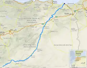
| Progression | Middle Atlas - Hassan II Dam - Mohamed V Dam - Mediterranean Sea |
| Official name | Embouchure de la Moulouya |
| Designated | 15 January 2005 |
| Reference no. | 1478[1] |
Water level in the river often fluctuates. The river is used for irrigation and is dammed by the Hassan II and Mohamed V Dams.
History
The Romans called this river Malva. The Moulouya River formed the eastern border of the Rif Republic in the 1920s, a small part of Morocco containing important cities like Saïdia and Oujda lying to the east, between the Moulouya and the border with Algeria. Until 1956 the river also formed the eastern border of the Spanish Protectorate of Morocco.
.jpg.webp)
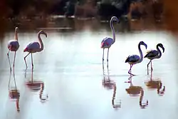
Ecology
In August 2011 fish were killed by pollutants in the Moulouya River and local residents feared for their crops and livestock.[3]
References
- "Embouchure de la Moulouya". Ramsar Sites Information Service. Retrieved 25 April 2018.
- Peyron, M. (1990). "'Ayyachi, Jbel". Encyclopédie berbère. 8. Edisud. pp. 1200–1204.
- "Ecological disaster mars Morocco's Moulouya River". Magharebia. August 2011.