Mount Hebron
Mount Hebron, or the Hebron hills (Arabic: جبل الخليل, Hebrew: הר חברון) are a mountain ridge, geographic region, and geologic formation, comprising the bulk of the central Judean Mountains in the West Bank.
| Mount Hebron | |
|---|---|
| Highest point | |
| Elevation | 1,026 m (3,366 ft) |
| Prominence | 1,026 m (3,366 ft) |
| Listing | Country high point |
| Coordinates | |
| Geography | |
| Location | Levant |
Geography
The highest peak of the mountain ridge is in the Palestinian city of Halhul, where a tableland exists with an altitude of 1,026 metres (3,366 ft). The ridge continues south towards Arad in Israel, and was called as the mountain road between Hebron and Jerusalem.
The Hebron hills are located in the southern West Bank,[1][2] with its western foothills extending into Israel.[3]
History
In biblical times, the region was a center of the Israelite kingdom and later the Hasmonean and Herodian kingdoms.
During the Crusades, at the time of the Kingdom of Jerusalem, all the Hebron hills fell under the dominion of the seigneurie of St.Abraham.[4]
In recent times has declared several areas where traditional Palestinian herding communities live as restricted military zones, forcing the displacement of many families. Several Israeli settlements have been established over the terrain. The Israeli military administration regards the area as a high priority for enforcing demolition orders regarding Palestinian dwellings.[5]
Flora and fauna
The Hebron Hills form the southern and eastern border of Mediterranean vegetation in historical Palestine.
A 2012 survey by the Israel Nature and Parks Authority discovered 54 rare plant species in the region, more than half of them in cultivated fields. They include Boissiera squarrosa, a type of grass; Legousia hybrida, a plant from the bellflower family; and Resesda globulosa, a rare mignonette.[6]
The region is known for its vineyards since biblical times. Palestinians and Israelis (from both parts of the Green Line) continue to farm grapes in this region. Local wineries include Yatir Winery.
References
- Mijal Grinberg (2007-02-14). "Security forces demolish seven houses in Mt. Hebron villages". Haaretz. Archived from the original on 16 February 2007. Retrieved 2014-01-26.
- Europa World Year Book 2. Taylor & Francis Group. p. 3308. ISBN 978-1-85743-255-8.
- Philip J. King (1983). American Archaeology in the Mideast. American Schools of Oriental Research. p. 217.
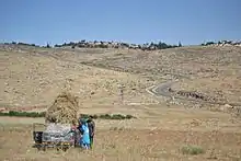
Kibbutz Lahav, located in the western foothills of Mount Hebron in Israel
- Claude Reignier Conder, The Latin Kingdom of Jerusalem, (1897) Routledge reprint 2005 ISBN 978-0-710-31080-4 p.78.
- Amira Hass,Hagar Shezaf, 'The Village Where Palestinians Are Rendered Completely Powerless,' Haaretz 5 January 2021
- Zafrir Rinat (15 March 2012). "Treasure trove of rare plants found in Israel's Hebron Hills". Haaretz. Retrieved 26 January 2014.