Mount Mellenthin
Mount Mellenthin is a 12,645-foot (3,854 meter) elevation summit located in San Juan County of Utah, United States.[3] Mount Mellenthin is the second-highest peak of the La Sal Mountains. It is situated in a dry, rugged, sparsely settled region, and set on land administered by Manti-La Sal National Forest. Precipitation runoff from this mountain drains into tributaries of the Colorado River. The nearest town is Moab, 20 mi (32 km) to the northwest, and the nearest higher neighbor is Mount Peale, 1.7 mi (2.7 km) to the south. The mountain's name honors Rudolf E. Mellenthin (1884–1918), forest ranger of La Sal National Forest, who was shot to death near this peak on August 23, 1918, while attempting to apprehend two draft evaders.[3] This geographical feature's name was officially adopted in 1932 by the U.S. Board on Geographic Names.[3]
| Mount Mellenthin | |
|---|---|
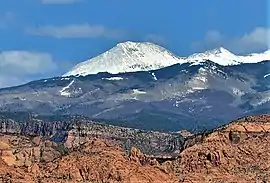 West aspect | |
| Highest point | |
| Elevation | 12,645 ft (3,854 m) [1] |
| Prominence | 645 ft (197 m) [1] |
| Parent peak | Mount Peale (12,721 ft)[2] |
| Isolation | 1.75 mi (2.82 km) [2] |
| Coordinates | 38°27′47″N 109°14′02″W [3] |
| Geography | |
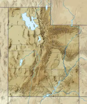 Mount Mellenthin Location in Utah  Mount Mellenthin Mount Mellenthin (the United States) | |
| Location | San Juan County, Utah, U.S. |
| Parent range | La Sal Mountains |
| Topo map | USGS Mount Peale |
| Geology | |
| Age of rock | Oligocene |
| Mountain type | Laccolith |
| Climbing | |
| Easiest route | class 2 [2] |
Climate
Spring and fall are the most favorable seasons to visit Mount Mellenthin. According to the Köppen climate classification system, it is located in a Cold semi-arid climate zone, which is defined by the coldest month having an average mean temperature below 32 °F (0 °C), and at least 50% of the total annual precipitation being received during the spring and summer. This desert climate receives less than 10 inches (250 millimeters) of annual rainfall, and snowfall is generally light during the winter.
Gallery
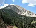 East aspect
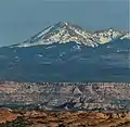 From Arches National Park
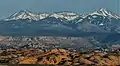 Mount Mellenthin (left), Mount Tukuhnikivatz (right)
References
- "Mount Mellenthin". Peakbagger.com. Retrieved 2020-09-17.
- "Mellenthin, Mount - 12,645' UT". listsofjohn.com. Retrieved 2020-09-17.
- "Mount Mellenthin". Geographic Names Information System. United States Geological Survey. Retrieved 2020-09-17.
External links
- Weather forecast: Mount Mellenthin
- Rudolf Emil Mellenthin: Utahsfallen.org