Mount Moturau
Mount Moturau is a mountain at height 1,497 m, rising south west of the Hope Arm of Lake Manapouri and clearly visible from Manapouri township. Note: Topographic map C44, Hunter Mountains, GR 2080950E 5497500N. Not named on official mapping pre 10 May 2001.
| Mt Moturau | |
|---|---|
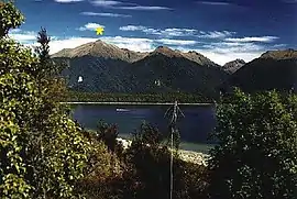 Mount Moturau, Lake Manapouri | |
| Highest point | |
| Elevation | 1,497 m (4,911 ft) |
| Prominence | 215 m (705 ft) |
| Coordinates | 45°35′0.4″S 167°28′26″E |
| Geography | |
| Location | South Island, New Zealand |
| Topo map | 260-C44 |
| Climbing | |
| First ascent | J Calder |
| Easiest route | Bicycle Spur Trail |
History
The name Moturau was originally the Maori name for the summer village of what is now known as Manapouri. It is also the name of a tourist vessel on Lake Manapouri as well as a hut on the Kepler Track and was said to be an older name for Lake Manapouri itself.
This article is issued from Wikipedia. The text is licensed under Creative Commons - Attribution - Sharealike. Additional terms may apply for the media files.