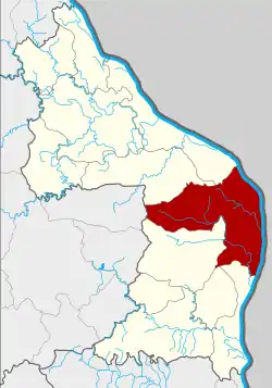
Mueang Nakhon Phanom District
Mueang Nakhon Phanom (Thai: เมืองนครพนม, pronounced [mɯ̄a̯ŋ ná(ʔ).kʰɔ̄ːn pʰā.nōm])) is the capital district (amphoe mueang) of Nakhon Phanom Province, northeastern Thailand.
Mueang Nakhon Phanom
เมืองนครพนม | |
|---|---|
 District location in Nakhon Phanom Province | |
| Coordinates: 17°22′2″N 104°45′38″E | |
| Country | Thailand |
| Province | Nakhon Phanom |
| Seat | Nong Yat |
| Area | |
| • Total | 853.20 km2 (329.42 sq mi) |
| Population (2008) | |
| • Total | 141,997 |
| • Density | 122.7/km2 (318/sq mi) |
| Time zone | UTC+7 (ICT) |
| Postal code | 48000 |
| Geocode | 4801 |
Geography
Neighboring districts are (from the south clockwise): That Phanom, Renu Nakhon of Nakhon Phanom Province; Kusuman of Sakon Nakhon Province; Pla Pak and Tha Uthen of Nakhon Phanom Province. To the east across the Mekong River is the Laotian province Khammouan.
History
In 1917 the district name was changed from Mueang to Nong Buek (หนองบึก).[1] In 1938 it was renamed Mueang Nakhon Phanom.[2]
Economy
Khok Phu Kratae and Phai Lom villages in At Samat Subdistrict will be the site of a special economic zone (SEZ). As many as 400 families are to be evicted in the course of the project. Gen Prayut Chan-o-cha, head of the junta's National Council for Peace and Order (NCPO) and prime minister, in May 2015 invoked his authority under Section 44 of the Interim Charter to announce NCPO Order No. 17/2015. The order mandates turning large areas in Tak, Mukdahan, Nong Khai, Sa Kaeo, and Trat provinces into special economic zones (SEZs), where deregulation of industry and tax cuts are offered to lure investors. In addition to the pilot SEZ projects in these five provinces, more land in five other provinces, Chiang Rai, Nakhon Phanom, Kanchanaburi, Songkhla, and Narathiwat, are to be expropriated and cleared for SEZs.[3]
Administration
The district is divided into 15 sub-districts (tambons), which are further subdivided into 169 villages (mubans). The town (thesaban mueang) Nakhon Phanom covers tambon Nai Mueang and Nong Saeng and parts of tambons At Samat and Nong Yat. There are a further 13 tambon administrative organizations (TAO).
| No. | Name | Thai | Villages | Pop.[4] |
|---|---|---|---|---|
| 1. | Nai Mueang | ในเมือง | - | 16,771 |
| 2. | Nong Saeng | หนองแสง | - | 4,691 |
| 3. | Na Sai | นาทราย | 13 | 5,784 |
| 4. | Na Rat Khwai | นาราชควาย | 9 | 7,277 |
| 5. | Kurukhu | กุรุคุ | 13 | 7,938 |
| 6. | Ban Phueng | บ้านผึ้ง | 23 | 15,787 |
| 7. | At Samat | อาจสามารถ | 11 | 9,771 |
| 8. | Kham Thao | ขามเฒ่า | 11 | 8,721 |
| 9. | Ban Klang | บ้านกลาง | 13 | 8,554 |
| 10. | Tha Kho | ท่าค้อ | 14 | 8,813 |
| 11. | Kham Toei | คำเตย | 18 | 12,135 |
| 12. | Nong Yat | หนองญาติ | 13 | 14,372 |
| 13. | Dong Khwang | ดงขวาง | 11 | 6,500 |
| 14. | Wang Ta Mua | วังตามัว | 11 | 8,302 |
| 15. | Pho Tak | โพธิ์ตาก | 9 | 6,581 |
References
- ประกาศกระทรวงมหาดไทย เรื่อง เปลี่ยนชื่ออำเภอ (PDF). Royal Gazette (in Thai). 34 (0 ก): 40–68. 29 April 1917.
- พระราชกฤษฎีกาเปลี่ยนนามจังหวัด และอำเภอบางแห่ง พุทธศักราช ๒๔๘๑ (PDF). Royal Gazette (in Thai). 55 (0 ก): 658–666. 14 November 1938.
- "Junta set to evict Isan villagers for Special Economic Zone". Pratchathai English. 2 November 2015. Retrieved 6 November 2015.
- "Population statistics 2008". Department of Provincial Administration. Archived from the original on 16 September 2009.