Nahal Paran
Nahal Paran (Hebrew: נחל פארן) is an occasionally dry riverbed in Israel's Negev Desert and Egypt's Sinai Peninsula. With a length of 150 kilometers, this is the third largest river in Israel after the Jordan River and Yarmouk River. It is also the widest river in Israel.
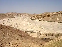
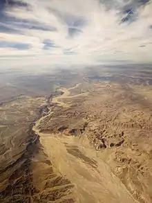
The origin of the river is in the Paran Desert of the Sinai Peninsula, and it flows into the estuary of Nahal HaArava. Water flow exists only during flash floods. This is the drainage basin's largest river, with an area of thousands of square kilometers, creating broad planes that separate the Negev's high north and the Eilat mountains of the south.[1]
In the past, during floods, like other major rivers in the Negev, Nahal paran would flood the Arava Road (the main road to Eilat), until the construction of a bridge over the river. The stream had the highest recorded flow in Israel of 1,150 cubic meters per second on 6 November 1970. In 2014, it broke this record was broken by a flow of 1,280 cubic meters per second measured at Zin. For comparison, the average flow in the Jordan River is 16 cubic meters per second.
Ground water near the riverbed provides drinking water for communities in the Arava desert. This water has high salinity and goes through desalination.
References
- Wohl, Ellen E.; Greenbaum, Noam; Schick, Ascher P.; Baker, Victor R. (1994). "Controls on bedrock channel incision along nahal paran, Israel". Earth Surface Processes and Landforms. 19 (1): 1. doi:10.1002/esp.3290190102.