Nakhon Chai Si District
Nakhon Chai Si District (Thai: นครชัยศรี, pronounced [ná(ʔ).kʰɔ̄ːn t͡ɕʰāj sǐː]) is a district (amphoe) of Nakhon Pathom Province, central Thailand.
Nakhon Chai Si
นครชัยศรี | |
|---|---|
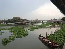 The Tha Chin River flowing through Nakhon Chai Si Sub-district where it is called the "Nakhon Chai Si River". | |
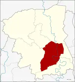 District location in Nakhon Pathom Province | |
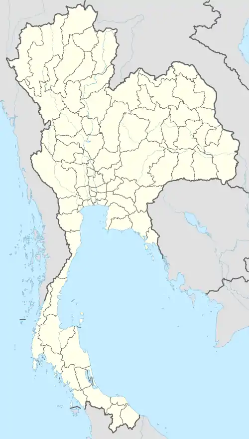 Nakhon Chai Si Location in Thailand | |
| Coordinates: 13°48′4″N 100°11′16″E | |
| Country | Thailand |
| Province | Nakhon Pathom |
| Seat | Nakhon Chai Si |
| Area | |
| • Total | 284.031 km2 (109.665 sq mi) |
| Population (2017) | |
| • Total | 111,119 |
| • Density | 391.22/km2 (1,013.3/sq mi) |
| Time zone | UTC+7 (ICT) |
| Postal code | 73120 |
| Geocode | 7303 |
History
It was established in the reign of King Maha Chakkraphat of Ayutthaya kingdom. When King Chulalongkorn created the Monthon as part of the Thesaphiban administrative reform, Mueang Nakhon Chai Si was the capital city of Monthon Nakhon Chai Si. Later when the government gave up the system, Mueang Nakhon Chai Si was downgraded to be a district of Nakhon Pathom.
More than 1,000 years ago, Han Chinese called Nakhon Chai Si (including other districts in this region, such as Samut Sakhon) according Teochew dialect that Lang-Ka-Su (Chinese: 龍仔厝; pinyin: Lóng zǐ cuò), refers to 'home of dragon descendant'. Because the Tha Chin River flows through the winding like a serpent or dragon.[1]
Geography
Neighboring districts are (from the north clockwise): Bang Len, Phutthamonthon, Sam Phran, Mueang Nakhon Pathom, and Don Tum.
The main water resource is the Tha Chin River, which is named Nakhon Chai Si River in the area of and around the district.
Economy
In mid-2019, the Department of Airports (DOA) proposed the construction of a new airport in Nakhon Pathom Province, 50 kilometres west of Bangkok, to relieve pressure on Bangkok's two existing airports. The 20 billion baht airport would occupy 3,500 rai of land in Nakhon Chai Si District as well as Bang Len. Its capacity would be 25 million passengers annually. If approved, construction would start in 2023 and the airport would be operational by 2025 or 2026.[2]
Administration
The district is divided into 24 sub-districts (tambons), which are further subdivided into 108 villages (mubans). Both Nakhon Chai Si and Huai Phlu have sub-district municipality (thesaban tambon) status. Each of the tambons has a tambon administrative organization (TAO).
| No. | Name | Thai | Villages | Pop.[3] |
|---|---|---|---|---|
| 1. | Nakhon Chai Si | นครชัยศรี | 3 | 2,957 |
| 2. | Bang Krabao | บางกระเบา | 3 | 1,032 |
| 3. | Wat Khae | วัดแค | 4 | 2,010 |
| 4. | Tha Tamnak | ท่าตำหนัก | 4 | 6,521 |
| 5. | Bang Kaeo | บางแก้ว | 4 | 3,339 |
| 6. | Tha Krachap | ท่ากระชับ | 4 | 3,960 |
| 7. | Khun Kaeo | ขุนแก้ว | 4 | 7,734 |
| 8. | Tha Phraya | ท่าพระยา | 5 | 3,674 |
| 9. | Phaniat | พะเนียด | 4 | 3,858 |
| 10. | Bang Rakam | บางระกำ | 4 | 4,886 |
| 11. | Khok Phra Chedi | โคกพระเจดีย์ | 5 | 4,746 |
| 12. | Sisa Thong | ศรีษะทอง | 5 | 7,291 |
| 13. | Laem Bua | แหลมบัว | 8 | 7,151 |
| 14. | Si Maha Pho | ศรีมหาโพธิ์ | 5 | 4,096 |
| 15. | Sam Pot Won | สัมปทวน | 6 | 3,824 |
| 16. | Wat Samrong | วัดสำโรง | 4 | 1,883 |
| 17. | Don Faek | ดอนแฝก | 4 | 3,017 |
| 18. | Huai Phlu | ห้วยพลู | 4 | 2,473 |
| 19. | Wat Lamut | วัดละมุด | 5 | 5,562 |
| 20. | Bang Phra | บางพระ | 4 | 2,750 |
| 21. | Bang Kaeo Fa | บางแก้วฟ้า | 5 | 3,134 |
| 22. | Lan Tak Fa | ลานตากฟ้า | 5 | 7,858 |
| 23. | Ngio Rai | งิ้วราย | 4 | 2,925 |
| 24. | Thaiyawat | ไทยาวาส | 4 | 2,930 |
References
- Sujit Wongthes, "เล่งเกียฉู่" แม่น้ำท่าจีน หลักแหล่งลูกหลานมังกร ("Lang-Ka-Su" Tha Chin River residence of dragon descendant), Matichon, Vol. 42 Issue 15066 (11 June 2019) Thai: ภาษาไทย
- Hongtong, Thodsapol (20 July 2019). "Third Bangkok airport proposed". Bangkok Post. Retrieved 25 July 2019.
- "Population statistics 2015". Department of Provincial Administration.