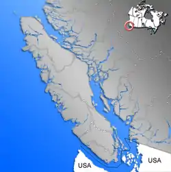
Nanaimo Lakes
Nanaimo Lakes comprise First, Second, and Third Lakes, natural lakes on the upper Nanaimo River, on Vancouver Island in British Columbia, as well as Fourth Lake, behind a dam impounding the river.
| Nanaimo Lakes | |
|---|---|
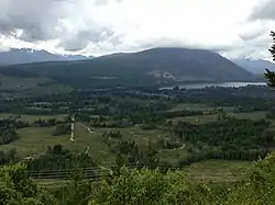 First Lake | |
 Nanaimo Lakes | |
| Location | Regional District of Nanaimo, Vancouver Island, British Columbia[1] |
| Coordinates | 49°06′00″N 124°10′15″W[1] |
| Etymology | Snuneymuxw First Nation – city of Nanaimo |
| Part of | Nanaimo River |
| Catchment area | At least 23,000 hectares (57,000 acres)[2] |
| Basin countries | Canada |
| Max. length | 4 miles (6.4 km) |
| Surface elevation | 210 metres (690 ft)[3] |
Geography
The lakes are in a highland transitional area between the southern Vancouver Island Ranges and the Nanaimo Lowland.[4]
The 1:50,000 topographic map quadrangle "Nanaimo Lakes" published by Natural Resources Canada is centered on the lakes.[3] Note that lake names do not appear on all online mapping services, and Third Lake, not listed by the Watershed Roundtable, but listed in a 1919 guide, and on the Natural Resources Canada map, may not appear on some maps at all.[5] A lake with a dam at the north end, named "Fourth Lake", is also shown on the map. First Lake and Second Lake,at c. 210 meters above sea level,[3] are connected by a short stream.[6] Fourth Lake Dam is privately owned and impounds 38,000,000 cubic metres (1.3×10⁹ cu ft) of water, used for a paper mill.[7]
- First Lake 49°05′45″N 124°10′00″W,[3] natural, about 2 miles (3.2 km) long[6]
- Second Lake 49°05′45″N 124°13′00″W,[3] natural, about 2 miles (3.2 km) long[6]
- Third Lake 49°05′10″N 124°19′12″W,[8] natural, much smaller than the others
- Fourth Lake 49°03′31″N 124°25′12″W,[9] a reservoir, about 2.5 miles (4.0 km) long and 2 km2 in area[10]
Recreation
Timberwest owns has four campsites on private land surrounding First Lake.[11] The lake was stocked with up to 30,000 salmon or trout per year for recreational fishing beginning in 1905 through the early 21st century.[12][13][6] Fourth Lake can be kayaked.[10]
Nanaimo Lakes fire balloon
In March, 1945, a Fu-Go balloon bomb made in Yamaguchi Prefecture and launched from Japan landed at the lakes. Its firing circuits malfunctioned; it failed to detonate and was recovered and analyzed by a Canadian–American intelligence effort.[14]
Footnotes
References
- "Nanaimo Lakes". Geographical Names database. Natural Resources Canada. Retrieved 2018-07-10.
- "Watershed protection". City of Nanaimo. August 30, 2017. Retrieved 2018-07-10.
- Map 092F01, "Nanaimo Lakes" digital raster, published by Natural Resources Canada, 7th edition, March 24, 2011; accessed via ftp 2018-07-10
- Yorath 2005, p. 17.
- "Nanaimo River Watershed: location". Nanaimo River Watershed Roundtable. Retrieved 2018-07-10.
- Williams 1919, p. 70.
- Butler et al. 2014, p. 9.
- "Third Lake". BC Geographical Names database. Province of British Columbia Geographical Names Office. Retrieved 2018-07-10.
- "Fourth Lake". BC Geographical Names database. Province of British Columbia Geographical Names Office. Retrieved 2018-07-10.
- "Fourth Lake", Canoe & Kayak Paddling on Vancouver Island, retrieved 2018-07-10
- "Nanaimo Lakes campsites". Timberwest. Retrieved 2018-07-10.
- "Fish stocking report – Nanaimo Lakes, Vancovuer Island". Freshwater Fisheries Society of BC. Retrieved 2018-07-10.
- Pochin 1946, p. 75.
- Coen 2014, p. 157.
Sources
- Butler, G.; Chapman, P.; Gullison, R.E.; Kellow, M.; Walker, S.; Wolf, J. (2014), Nanaimo River Baseline Report: social, environmental and economic values of the Nanaimo River and watershed (PDF) (2nd ed.) Unpublished report prepared for the Nanaimo & Area Land Trust. 312 pp.
- Coen, R. (2014). Fu-go: The Curious History of Japan's Balloon Bomb Attack on America. Studies in War, Society, and the Military Series. University of Nebraska Press. ISBN 978-0-8032-5667-5.CS1 maint: ref=harv (link)
- Pochin, W.F. (1946). Angling and Hunting in British Columbia. Sun Directories.CS1 maint: ref=harv (link)
- Williams, A.B. (1919). Rod & Creel in British Columbia. Progress Publishing Company. p. 143. Retrieved 2018-07-10.CS1 maint: ref=harv (link)
- Yorath, C.J. (2005). The Geology of Southern Vancouver Island. Harbour Pub. ISBN 978-1-55017-362-8.CS1 maint: ref=harv (link)
Further reading
- Davies, Gordon (1996). Living Rivers of British Columbia & Yukon. Living River of British Columbia & the Yukon. Ronsdale Press. ISBN 978-0-921870-37-1.CS1 maint: ref=harv (link)