Napoleon Pass
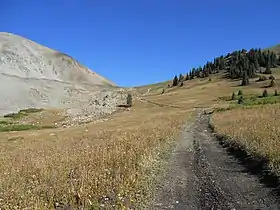
Napoleon Pass (elevation 12,034 feet (3,668 m)) is a high mountain pass in the Sawatch Range of the Rocky Mountains of Colorado. It is located in Gunnison County and in the Gunnison National Forest. The pass is the saddle between Napoleon Mountain to the west and Fitzpatrick Peak to the east and divides the watersheds of Middle Willow Creek to the north and Quartz Creek to the south. Napoleon Pass is traversed by Forest Trail 540 and can be accessed from the towns of Tincup to the north and Pitkin to the south.[1][2][3]
| Napoleon Pass | |
|---|---|
 Napoleon Pass | |
| Elevation | 12,034 ft (3,668 m)[1] |
| Traversed by | Forest Trail 540 |
| Location | Gunnison County, Colorado, U.S. |
| Range | Sawatch Range |
| Coordinates | 38°41′56″N 106°27′37″W[1] |
| Topo map | Cumberland Pass |
Napoleon Pass is named after "Frenchy" A. Napoleon Perrault, a long-time saloon proprietor in nearby Tincup.[2]
The Napoleon Pass wagon road was built in 1882 to connect the mining towns of Tin Cup to the north and Pitkin to the south. This road, along with the nearby Cumberland Pass road, allowed ore from Tincup-area mines to be shipped to the Quartz Station of the Denver & South Park Railroad. The ore was then shipped by rail east through the Alpine Tunnel.[2][4]
References
- "Napoleon Pass". Geographic Names Information System. United States Geological Survey.
- Helmuth, Ed; Helmuth, Gloria (1994). The Passes of Colorado: An Encyclopedia of Watershed Divides. Boulder, Colorado: Pruett Publishing Company. ISBN 0-87108-841-X.
- "Napoleon Pass Trail". trails.colorado.gov. Retrieved 29 December 2020.
- Vandenbusche, Duane (1980). The Gunnison Country. Gunnison, Colorado: B&B Printers. LCCN 80-070455.
External links
- Napoleon Pass, passbagger.org