National Register of Historic Places listings in Chambers County, Alabama
This is a list of the National Register of Historic Places listings in Chambers County, Alabama.
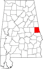
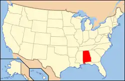
Location of Chambers County in Alabama
This is intended to be a complete list of the properties and districts on the National Register of Historic Places in Chambers County, Alabama, United States. Latitude and longitude coordinates are provided for many National Register properties and districts; these locations may be seen together in a Google map.[1]
There are 10 properties and districts listed on the National Register in the county.
- This National Park Service list is complete through NPS recent listings posted February 5, 2021.[2]
| [3] | Name on the Register | Image | Date listed[4] | Location | City or town | Description |
|---|---|---|---|---|---|---|
| 1 | Bethlehem Baptist Church | 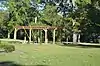 Bethlehem Baptist Church |
December 7, 2017 (#100001875) |
Southern corner of River and White's Mill Rds. 32°47′19″N 85°10′35″W |
Valley | |
| 2 | Chambers County Courthouse Square Historic District | .JPG.webp) Chambers County Courthouse Square Historic District |
March 27, 1980 (#80000682) |
Roughly bounded by Alabama and 2nd Aves. and 1st St. 32°53′58″N 85°24′03″W |
La Fayette | |
| 3 | County Line Baptist Church | 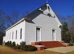 County Line Baptist Church |
August 19, 1982 (#82002001) |
East of Dudleyville 32°55′04″N 85°35′23″W |
Dudleyville | Erected c. 1890 |
| 4 | Fairfax Historic District | 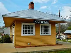 Fairfax Historic District |
September 24, 1999 (#99001177) |
Roughly bounded by River Rd., Spring St., Lanier St., Denson St., Combs St., and Cussetta Rd. 32°47′35″N 85°10′51″W |
Valley | |
| 5 | Langdale Historic District | 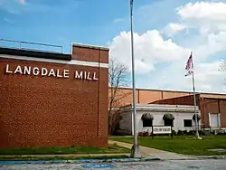 Langdale Historic District |
November 12, 1999 (#99001299) |
Roughly bounded by 65th St., 20th Ave., 61st, 58th, and 55th Sts., 16th Ave., and the Chattahoochee River 32°48′43″N 85°10′13″W |
Valley | |
| 6 | New Hope Rosenwald School | 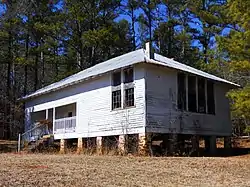 New Hope Rosenwald School |
November 29, 2001 (#01001297) |
2.25 miles southeast of U.S. Route 431 on County Road 267 32°56′36″N 85°17′08″W |
Fredonia | |
| 7 | Ernest McCarty Oliver House | January 21, 1974 (#74000402) |
LaFayette St., N./U.S. Route 431 32°54′24″N 85°24′09″W |
La Fayette | Large Victorian brick house, built from brick fired on site, facing east onto LaFayette St. N. | |
| 8 | Riverview Historic District | 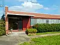 Riverview Historic District |
November 12, 1999 (#99001300) |
Roughly bounded by School and G.I. Sts., the Chattahoochee River, and along California St. 32°47′14″N 85°08′45″W |
River View | |
| 9 | Shawmut Historic District | 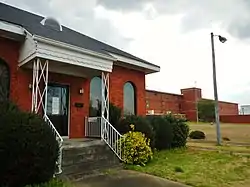 Shawmut Historic District |
September 24, 1999 (#99001176) |
Roughly bounded by 25th Boulevard, 29th Boulevard, 20th Ave., 35th St., and 38th Boulevard 32°50′25″N 85°11′00″W |
Valley | |
| 10 | Vines Funeral Home and Ambulance Service | 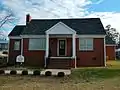 Vines Funeral Home and Ambulance Service |
October 15, 2008 (#08000434) |
211 B St. SW. 32°53′30″N 85°24′14″W |
La Fayette |
See also
| Wikimedia Commons has media related to National Register of Historic Places in Chambers County, Alabama. |
References
- The latitude and longitude information provided in this table was derived originally from the National Register Information System, which has been found to be fairly accurate for about 99% of listings. Some locations in this table may have been corrected to current GPS standards.
- "National Register of Historic Places: Weekly List Actions". National Park Service, United States Department of the Interior. Retrieved on February 5, 2021.
- Numbers represent an alphabetical ordering by significant words. Various colorings, defined here, differentiate National Historic Landmarks and historic districts from other NRHP buildings, structures, sites or objects.
- The eight-digit number below each date is the number assigned to each location in the National Register Information System database, which can be viewed by clicking the number.
Municipalities and communities of Chambers County, Alabama, United States | ||
|---|---|---|
| Cities | Map of Alabama highlighting Chambers County | |
| Towns | ||
| CDPs | ||
| Unincorporated communities | ||
| Ghost town | ||
| Footnotes | ‡This populated place also has portions in an adjacent county or counties | |
| ||
This article is issued from Wikipedia. The text is licensed under Creative Commons - Attribution - Sharealike. Additional terms may apply for the media files.