National Register of Historic Places listings in Cullman County, Alabama
This is a list of the National Register of Historic Places listings in Cullman County, Alabama.

Location of Cullman County in Alabama
This is intended to be a complete list of the properties and districts on the National Register of Historic Places in Cullman County, Alabama, United States. Latitude and longitude coordinates are provided for many National Register properties and districts; these locations may be seen together in a Google map.[1]
There are 9 properties and districts listed on the National Register in the county.
- This National Park Service list is complete through NPS recent listings posted February 5, 2021.[2]
| [3] | Name on the Register | Image | Date listed[4] | Location | City or town | Description |
|---|---|---|---|---|---|---|
| 1 | Ave Maria Grotto | .jpg.webp) Ave Maria Grotto |
January 19, 1984 (#84000610) |
St. Bernard Abbey 34°10′28″N 86°48′58″W |
Cullman | |
| 2 | Clarkson Bridge | 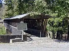 Clarkson Bridge |
June 25, 1974 (#74000408) |
West of Cullman 34°12′27″N 86°59′28″W |
Cullman | |
| 3 | Crane Hill Masonic Lodge | 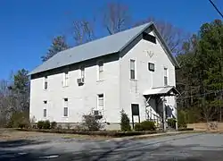 Crane Hill Masonic Lodge |
November 29, 2001 (#01001294) |
14538 County Road 222 34°05′49″N 87°03′16″W |
Crane Hill | |
| 4 | Cullman Downtown Commercial Historic District | 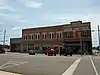 Cullman Downtown Commercial Historic District |
April 11, 1985 (#85000738) |
Roughly bounded by 4th and 1st Aves. and 2nd and 5th Sts., SE. 34°10′33″N 86°50′24″W |
Cullman | |
| 5 | Cullman Historic District | 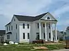 Cullman Historic District |
August 30, 1984 (#84000615) |
Roughly bounded by 1st and 8th Aves. and 3rd and 9th Sts. 34°10′26″N 86°49′58″W |
Cullman | |
| 6 | Ernest Edward Greene House | 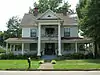 Ernest Edward Greene House |
February 3, 1993 (#92001828) |
105 6th Ave., SE. 34°10′45″N 86°50′16″W |
Cullman | |
| 7 | Louisville and Nashville Railroad Depot | 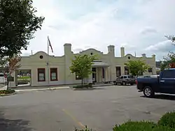 Louisville and Nashville Railroad Depot |
June 17, 1976 (#76000320) |
309 1st Ave., NE. 34°10′48″N 86°50′39″W |
Cullman | |
| 8 | Shady Grove Methodist Church and Cemetery | 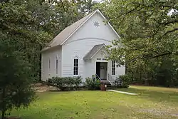 Shady Grove Methodist Church and Cemetery |
October 3, 2002 (#02001067) |
Ruby Community 3.7 miles west of Logan 34°08′29″N 87°02′08″W |
Logan | |
| 9 | Stiefelmeyer's | 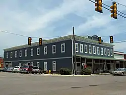 Stiefelmeyer's |
December 22, 1983 (#83003444) |
202 1st Ave., SE. 34°10′35″N 86°50′32″W |
Cullman |
See also
| Wikimedia Commons has media related to National Register of Historic Places in Cullman County, Alabama. |
References
- The latitude and longitude information provided in this table was derived originally from the National Register Information System, which has been found to be fairly accurate for about 99% of listings. Some locations in this table may have been corrected to current GPS standards.
- "National Register of Historic Places: Weekly List Actions". National Park Service, United States Department of the Interior. Retrieved on February 5, 2021.
- Numbers represent an alphabetical ordering by significant words. Various colorings, defined here, differentiate National Historic Landmarks and historic districts from other NRHP buildings, structures, sites or objects.
- The eight-digit number below each date is the number assigned to each location in the National Register Information System database, which can be viewed by clicking the number.
Municipalities and communities of Cullman County, Alabama, United States | ||
|---|---|---|
| Cities | Map of Alabama highlighting Cullman County | |
| Towns | ||
| CDPs | ||
| Unincorporated communities | ||
| Footnotes | ‡This populated place also has portions in an adjacent county or counties | |
| ||
This article is issued from Wikipedia. The text is licensed under Creative Commons - Attribution - Sharealike. Additional terms may apply for the media files.