National Register of Historic Places listings in Lincoln County, Nevada
Contents: List of Registered Historic Places in Lincoln County, Nevada, USA:
The locations of National Register properties and districts (at least for all showing latitude and longitude coordinates below), may be seen in an online map by clicking on "Map of all coordinates".[1]
- This National Park Service list is complete through NPS recent listings posted January 29, 2021.[2]
Current listings
| [3] | Name on the Register | Image | Date listed[4] | Location | City or town | Description |
|---|---|---|---|---|---|---|
| 1 | 1938 Lincoln County Courthouse | 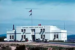 1938 Lincoln County Courthouse |
July 25, 2002 (#02000820) |
1 Main St. 37°56′13″N 114°27′02″W |
Pioche | |
| 2 | Black Canyon Petroglyphs | 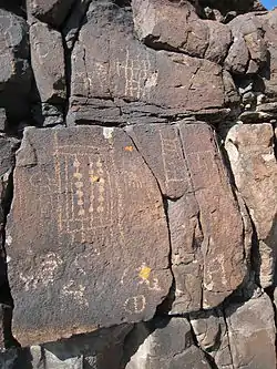 Black Canyon Petroglyphs |
May 27, 1975 (#75001113) |
Pahranagat National Wildlife Refuge[5] Address Restricted |
Alamo | |
| 3 | Bristol Wells Town Site | 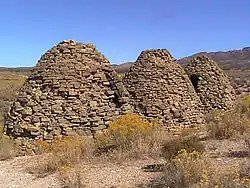 Bristol Wells Town Site |
March 24, 1972 (#72000765) |
23 miles north of Pioche off U.S. Route 93 38°06′22″N 114°41′42″W |
Pioche | |
| 4 | Brown's Hall-Thompson's Opera House | .jpg.webp) Brown's Hall-Thompson's Opera House |
August 16, 1984 (#84002074) |
N. Main St. 37°55′48″N 114°27′02″W |
Pioche | |
| 5 | Caliente Railroad Depot | 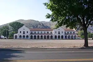 Caliente Railroad Depot |
March 5, 1974 (#74001146) |
100 Depot Ave. 37°36′45″N 114°30′51″W |
Caliente | |
| 6 | Lincoln County Courthouse | 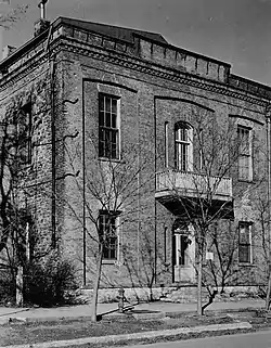 Lincoln County Courthouse |
February 23, 1978 (#78001724) |
Lacour St. 37°55′54″N 114°27′07″W |
Pioche | |
| 7 | Panaca Summit Archeological District | March 19, 1990 (#90000362) |
Address Restricted |
Panaca | ||
| 8 | Pioche Firehouse | February 5, 2018 (#100002070) |
Lots 3 & 32, Block 1 of Pioche Townsite, N of Main St. & Lacour 37°55′47″N 114°27′06″W |
Pioche | ||
| 9 | Smith Hotel-Cornelius Hotel | June 10, 2008 (#08000510) |
100 Spring St. 37°37′05″N 114°30′59″W |
Caliente | See this story. | |
| 10 | White River Narrows Archeological District | 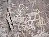 White River Narrows Archeological District |
August 1, 1978 (#78001723) |
Weepah Spring Wilderness Address Restricted |
Hiko |
See also
| Wikimedia Commons has media related to National Register of Historic Places in Lincoln County, Nevada. |
References
- The latitude and longitude information provided in this table was derived originally from the National Register Information System, which has been found to be fairly accurate for about 99% of listings. Some locations in this table may have been corrected to current GPS standards.
- "National Register of Historic Places: Weekly List Actions". National Park Service, United States Department of the Interior. Retrieved on January 29, 2021.
- Numbers represent an alphabetical ordering by significant words. Various colorings, defined here, differentiate National Historic Landmarks and historic districts from other NRHP buildings, structures, sites or objects.
- The eight-digit number below each date is the number assigned to each location in the National Register Information System database, which can be viewed by clicking the number.
- "Black Canyon Petroglyph Site". Bradshaw Foundation. Retrieved 2013-11-16.
This article is issued from Wikipedia. The text is licensed under Creative Commons - Attribution - Sharealike. Additional terms may apply for the media files.