National Register of Historic Places listings in Storey County, Nevada
Contents: List of Registered Historic Places in Storey County, Nevada, USA:
The locations of National Register properties and districts (at least for all showing latitude and longitude coordinates below), may be seen in an online map by clicking on "Map of all coordinates".[1]
- This National Park Service list is complete through NPS recent listings posted January 29, 2021.[2]
Current listings
| [3] | Name on the Register | Image | Date listed[4] | Location | City or town | Description |
|---|---|---|---|---|---|---|
| 1 | Chollar Mansion | 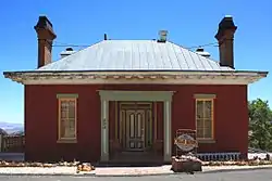 Chollar Mansion |
August 5, 1993 (#93000689) |
565 S. D St. 39°18′10″N 119°39′03″W |
Virginia City | |
| 2 | Derby Diversion Dam |  Derby Diversion Dam |
April 26, 1978 (#78001727) |
19 miles (30.4 km) east of Sparks on Interstate 80 39°35′09″N 119°26′49″W |
Sparks | Extends into Washoe County |
| 3 | King-McBride Mansion | 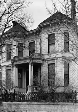 King-McBride Mansion |
September 4, 1998 (#98001086) |
26-28 S. Howard St. 39°18′38″N 119°39′03″W |
Virginia City | |
| 4 | Lagomarsino Petroglyph Site | 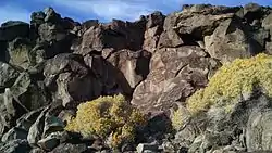 Lagomarsino Petroglyph Site |
March 24, 1978 (#78001728) |
Address Restricted |
Virginia City | |
| 5 | Marlette Lake Water System | 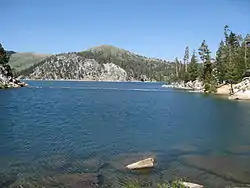 Marlette Lake Water System |
September 16, 1992 (#92001162) |
Roughly from Marlette Lake east to State Route 80 39°13′15″N 119°49′17″W |
Virginia City | |
| 6 | McCarthy House | 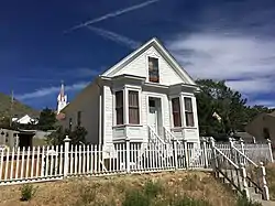 McCarthy House |
October 31, 1995 (#95001231) |
50 S. I St. 39°18′30″N 119°38′48″W |
Virginia City | |
| 7 | Parish House | 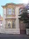 Parish House |
August 5, 1993 (#93000688) |
109 S. F St. 39°18′33″N 119°38′48″W |
Virginia City | |
| 8 | Piper's Opera House | 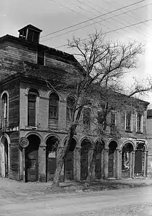 Piper's Opera House |
March 21, 1997 (#97000217) |
1, 3, and 5 N. B St. 39°18′39″N 119°39′06″W |
Virginia City | |
| 9 | Piper-Beebe House | 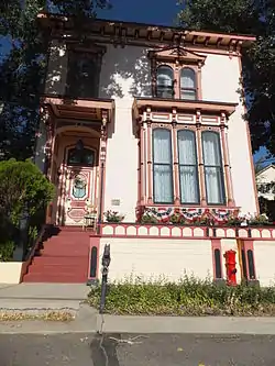 Piper-Beebe House |
August 5, 1993 (#93000684) |
2 South A St. 39°18′40″N 119°38′59″W |
Virginia City | |
| 10 | Henry Piper House | 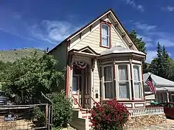 Henry Piper House |
May 4, 2011 (#11000254) |
58 North B St. 39°18′42″N 119°38′59″W |
Virginia City | |
| 11 | C.J. Prescott House | 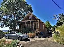 C.J. Prescott House |
August 5, 1993 (#93000687) |
12 Hickey St. 39°18′12″N 119°39′05″W |
Virginia City | |
| 12 | Virginia City Historic District | 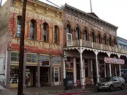 Virginia City Historic District |
October 15, 1966 (#66000458) |
Virginia City and its environs 39°15′35″N 119°35′19″W |
Virginia City | Extends into Lyon County |
See also
| Wikimedia Commons has media related to National Register of Historic Places in Storey County, Nevada. |
References
- The latitude and longitude information provided in this table was derived originally from the National Register Information System, which has been found to be fairly accurate for about 99% of listings. Some locations in this table may have been corrected to current GPS standards.
- "National Register of Historic Places: Weekly List Actions". National Park Service, United States Department of the Interior. Retrieved on January 29, 2021.
- Numbers represent an alphabetical ordering by significant words. Various colorings, defined here, differentiate National Historic Landmarks and historic districts from other NRHP buildings, structures, sites or objects.
- The eight-digit number below each date is the number assigned to each location in the National Register Information System database, which can be viewed by clicking the number.
This article is issued from Wikipedia. The text is licensed under Creative Commons - Attribution - Sharealike. Additional terms may apply for the media files.