National Weather Service Baltimore/Washington
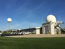
The National Weather Service Baltimore/Washington is a local office of the National Weather Service responsible for monitoring weather conditions in 44 counties in eastern West Virginia, northern and central Virginia, the majority of the state of Maryland, as well as the city of Washington, D.C. Although labeled as the NWS Baltimore/Washington, its actual location is off Old Ox Road (Virginia State Route 606) in the Dulles section of Sterling, Virginia, adjacent to Washington Dulles International Airport.
 | |
| Types | branch |
|---|---|
| Location | Sterling |
| Country | United States |
| Coordinates | 38°58′35″N 77°29′08″W[1] |
| Website | www |
The NWS Baltimore/Washington currently employs about 25 people including meteorologists, support personnel, and management staff, working rotating shifts 24 hours a day, 7 days a week.
Effective November 10, 2020, the National Weather Service Baltimore/Washington will be responsible for Cecil County, Maryland, rather than the National Weather Service Mount Holly/Philadelphia. As of the same date, the National Weather Service Baltimore/Washington will be responsible for Garrett County, Maryland, rather than the National Weather Service Pittsburgh.[2]
Jurisdictions served
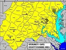
District of Columbia
Counties
- Allegany County
- Anne Arundel County
- Baltimore County
- Calvert County
- Carroll County
- Cecil County (from November 10, 2020)[3]
- Charles County
- Frederick County
- Garrett County (from November 10, 2020)[3]
- Harford County
- Howard County
- Montgomery County
- Prince George's County
- St. Mary's County
- Washington County
Independent city
Counties
- Albemarle County
- Arlington County
- Augusta County
- Clarke County
- Culpeper County
- Fairfax County
- Fauquier County
- Frederick County
- Greene County
- Highland County
- King George County
- Loudoun County
- Madison County
- Nelson County
- Orange County
- Page County
- Prince William County
- Rappahannock County
- Rockingham County
- Shenandoah County
- Spotsylvania County
- Stafford County
- Warren County
Independent cities
Aviation weather services locations
- Maryland
- Virginia
- West Virginia
First-order/climate sites
- Maryland
- Baltimore–Washington International Airport (Linthicum)
- Hagerstown Regional Airport
- Maryland Science Center (Baltimore)
- Virginia
- Charlottesville-Albemarle Airport
- Ronald Reagan Washington National Airport (Arlington)
- Washington Dulles International Airport (Chantilly/Sterling)
- West Virginia
- Eastern WV Regional Airport (Martinsburg)
NOAA Weather Radio
The National Weather Service Baltimore/Washington forecast office provides programming for eight NOAA Weather Radio stations.[5]
| City of license | Call sign | Frequency (MHz) | Power |
|---|---|---|---|
| Baltimore, Maryland | KEC83 | 162.400 MHz | 1,000 watts |
| Hagerstown, Maryland | WXM42 | 162.475 MHz | 1,000 watts |
| Manassas, Virginia | KHB36 | 162.550 MHz | 1,000 watts |
| Moorefield, West Virginia | WXM73 | 162.400 MHz | 500 watts |
| Frostburg, Maryland | WXM43 | 162.425 MHz | 300 watts |
| Charlottesville, Virginia | KZZ28 | 162.450 MHz | 1,000 watts |
| Washington, D.C. | WNG736 | 162.450 MHz | 300 watts |
| Fredericksburg, Virginia | WZ2527 | 162.425 MHz | 300 watts |
References
- https://www.weather.gov/lwx/.
- Berk, Justin (October 18, 2020). "National Weather Service Will Bring 2 More Maryland Counties Under One Office". Just In Weather.
- "Transfer of NWS Forecast & Warning Services for Maryland's Garrett & Cecil Counties to NWS Baltimore/Washington Effective November 10, 2020". NWS Baltimore/Washington. Retrieved 2020-10-18.
- "Local Climatology Reporting Locations". National Weather Service Sterling, VA. Retrieved 2014-06-12.
- NOAA All Hazards Weather Radio, NOAA. Retrieved August 2, 2018.