Nattages
Nattages is a former commune in the Ain department in eastern France. On 1 January 2016, it was merged into the new commune Parves-et-Nattages.[2]
Nattages | |
|---|---|
Part of Parves-et-Nattages | |
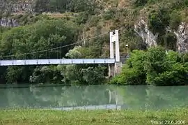 Suspension bridge over the Rhone | |
Location of Nattages 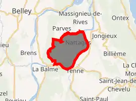
| |
 Nattages  Nattages | |
| Coordinates: 45°44′00″N 5°46′00″E | |
| Country | France |
| Region | Auvergne-Rhône-Alpes |
| Department | Ain |
| Arrondissement | Belley |
| Canton | Belley |
| Commune | Parves-et-Nattages |
| Area 1 | 10.33 km2 (3.99 sq mi) |
| Population (2017)[1] | 586 |
| • Density | 57/km2 (150/sq mi) |
| Time zone | UTC+01:00 (CET) |
| • Summer (DST) | UTC+02:00 (CEST) |
| Postal code | 01300 |
| Elevation | 220–663 m (722–2,175 ft) (avg. 310 m or 1,020 ft) |
| 1 French Land Register data, which excludes lakes, ponds, glaciers > 1 km2 (0.386 sq mi or 247 acres) and river estuaries. | |
It contains the ruins of the Chateau Montbel, the romanesque chapel of Chemillieu and a church rebuilt in the 17th century.
Population
| Year | Pop. | ±% |
|---|---|---|
| 1872 | 644 | — |
| 1876 | 596 | −7.5% |
| 1881 | 563 | −5.5% |
| 1886 | 554 | −1.6% |
| 1891 | 563 | +1.6% |
| 1896 | 540 | −4.1% |
| 1901 | 472 | −12.6% |
| 1906 | 506 | +7.2% |
| 1911 | 503 | −0.6% |
| 1921 | 393 | −21.9% |
| 1926 | 390 | −0.8% |
| 1931 | 351 | −10.0% |
| 1936 | 336 | −4.3% |
| 1946 | 322 | −4.2% |
| 1954 | 300 | −6.8% |
| 1962 | 266 | −11.3% |
| 1968 | 232 | −12.8% |
| 1975 | 231 | −0.4% |
| 1982 | 266 | +15.2% |
| 1990 | 322 | +21.1% |
| 1999 | 393 | +22.0% |
| 2008 | 549 | +39.7% |
See also
References
- Téléchargement du fichier d'ensemble des populations légales en 2017, INSEE
- Arrêté préfectoral 24 December 2015 (in French)
| Wikimedia Commons has media related to Nattages. |
| Authority control |
|---|
This article is issued from Wikipedia. The text is licensed under Creative Commons - Attribution - Sharealike. Additional terms may apply for the media files.