Navassa Island
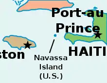
Navassa Island (/nəˈvæsə/; French: l'île de la Navasse; also La Navasse, La Navase) is a small uninhabited island in the Caribbean Sea. Located northeast of Jamaica, south of Cuba, 40 nautical miles (74 km; 46 mi) west of Jérémie on the south west peninsula of Haiti, it is subject to an ongoing territorial dispute between Haiti and the United States, which administers the island through the U.S. Fish and Wildlife Service.[1] The U.S. has claimed the island since 1857, based on the Guano Islands Act of 1856.[2] Haiti's claim over Navassa goes back to the Treaty of Ryswick in 1697 that established French possessions in mainland Hispaniola, that were transferred from Spain by the treaty[3] as well as other specifically named nearby islands. Its 1801 constitution also claimed unnamed "other adjacent islands", with Navassa not specifically named. Since its 1874 Constitution, and after the establishment of the 1857 U.S. claim, Haiti has explicitly named "la Navase" as one of the territories it claims.[5][6][7] Médéric Louis Élie Moreau de Saint-Méry, who was a member of the French Parliament best known for his publications on Saint-Domingue (now the Republic of Haiti), referred to la Navasse as the "small French island of Saint-Domingue" in 1798.[8][9][10]
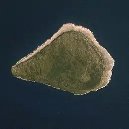 Navassa Island seen from the International Space Station | |
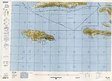
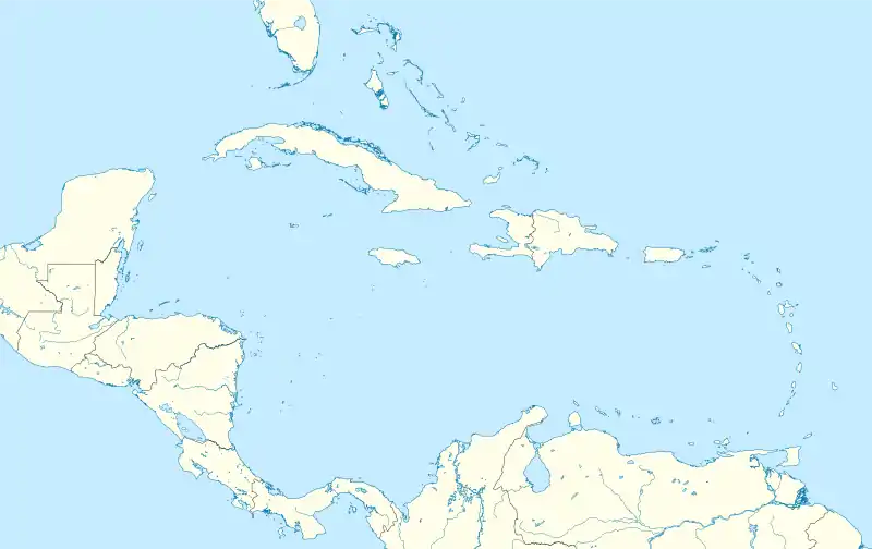 Navassa Island Location in the Caribbean | |
| Geography | |
|---|---|
| Location | Caribbean Sea |
| Coordinates | 18°24′10″N 75°0′45″W |
| Area | 5.4 km2 (2.1 sq mi) |
| Length | 4.7 km (2.92 mi) |
| Width | 2.1 km (1.3 mi) |
| Administration | |
History
1504 to 1901
In 1504, Christopher Columbus, stranded on Jamaica during his fourth voyage, sent some crew members by canoe to Hispaniola for help. They ran into the island on the way, but it had no water. They called it Navaza (from "nava-" meaning plain, or field), and it was avoided by mariners for the next 350 years.
From 1801 to 1867, the successive constitutions of Haiti claimed national sovereignty over adjacent islands, both named and unnamed, although Navassa was not specifically enumerated until 1874. Navassa Island was also claimed for the United States on September 19, 1857, by Peter Duncan, an American sea captain, under the Guano Islands Act of 1856, for the rich guano deposits found on the island, and for not being within the lawful jurisdiction of any other government, nor occupied by another government's citizens.[1]
Haiti protested the annexation, but on July 7, 1858, U.S. President James Buchanan issued an Executive Order upholding the American claim, which also called for military action to enforce it. Navassa Island has since been maintained by the United States as an unincorporated territory (according to the Insular Cases). The United States Supreme Court on November 24, 1890, in Jones v. United States, 137 U.S. 202 (1890) Id. at 224 found that Navassa Island must be considered as appertaining to the United States, creating a legal history for the island under U.S. law unlike many other islands originally claimed under the Guano Islands Act. As listed in its 1987 constitution, Haiti maintains its claim to the island.
Guano mining and the Navassa Island Rebellion of 1889
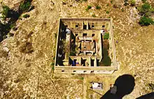
Guano phosphate is a superior organic fertilizer that became a mainstay of American agriculture in the mid-19th century. Duncan transferred his discoverer's rights to his employer, an American guano trader in Jamaica, who sold them to the newly formed Navassa Phosphate Company of Baltimore. After an interruption for the American Civil War, the company built larger mining facilities on Navassa with barrack housing for 140 black contract laborers from Maryland, houses for white supervisors, a blacksmith shop, warehouses, and a church.[11]
Mining began in 1865. The workers dug out the guano by dynamite and pick-axe and hauled it in rail cars to the landing point at Lulu Bay, where it was put into sacks and lowered onto boats for transfer to the Company barque, the S.S. Romance. The living quarters at Lulu Bay were called Lulu Town, as appears on old maps. Railway tracks eventually extended inland.
Hauling guano by muscle-power in the fierce tropical heat, combined with general disgruntlement with conditions on the island, eventually provoked a rebellion in 1889, in which five supervisors died. A U.S. warship returned 18 of the workers to Baltimore for three separate trials on murder charges. A black fraternal society, the Order of Galilean Fishermen, raised money to defend the miners in federal court, and the defense built its case on the contention that the men acted in self-defense or in the heat of passion, and that the United States did not have jurisdiction over the island.[12][13] E. J. Waring, the first black lawyer to pass the Maryland bar, was a part of the defense's legal team.[14]
The cases, including Jones v. United States, 137 U.S. 202 (1890), went to the U.S. Supreme Court in October 1890, which ruled the Guano Act constitutional, and three of the miners were scheduled for execution in the spring of 1891. A grass-roots petition driven by black churches around the country, also signed by white jurors from the three trials, reached President Benjamin Harrison, who commuted the sentences to imprisonment and mentioned the case in a State of the Union Address.[12][13] Guano mining resumed on Navassa at a much reduced level. The Spanish–American War of 1898 forced the Phosphate Company to evacuate the island and file for bankruptcy, and the new owners abandoned the island after 1901.
1901 to present
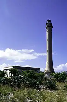
Navassa became significant again with the opening of the Panama Canal in 1914. Shipping between the American eastern seaboard and the Canal goes through the Windward Passage between Cuba and Haiti. Navassa, a hazard to navigation, needed a lighthouse. The U.S. Lighthouse Service built Navassa Island Light, a 162-foot (49-meter) tower on the island in 1917, 395 feet (120 meters) above sea level. A keeper and two assistants were assigned to live there until the Lighthouse Service installed an automatic beacon in 1929.[15]
After absorbing the Lighthouse Service in 1939, the U.S. Coast Guard serviced the light twice each year. The U.S. Navy set up an observation post for the duration of World War II. The island has been uninhabited since then. Fishermen, mainly from Haiti, fish the waters around Navassa.
A scientific expedition from Harvard University studied the land and marine life of the island in 1930. After World War II amateur radio operators occasionally visited to operate from the territory, which is accorded "entity" (country) status by the American Radio Relay League.[16] The callsign prefix is KP1.[16] From 1903 to 1917, Navassa was a dependency of the U.S. Guantanamo Bay Naval Base, and from 1917 to 1996, it was under United States Coast Guard administration.
In 1996, the Coast Guard dismantled the light on Navassa, which ended its interest in the island. Consequently, the Department of the Interior assumed responsibility for the civil administration of the area, and placed the island under its Office of Insular Affairs.[17] For statistical purposes, Navassa was grouped with the now-obsolete term United States Miscellaneous Caribbean Islands and is now grouped with other islands claimed by the U.S. under the Guano Islands Act as the United States Minor Outlying Islands.[18]
In 1997, an American salvager made a claim to Navassa to the Department of State based on the Guano Islands Act. On March 27, 1997, the Department of the Interior rejected the claim on the basis that the Guano Islands Act applies only to islands which, at the time of the claim, are not "appertaining to" the United States. The department's opinion said that Navassa is and remains a U.S. possession "appertaining to" the United States and is "unavailable to be claimed" under the Guano Islands Act.[1]
A 1998 scientific expedition led by the Center for Marine Conservation in Washington, D.C., described Navassa as "a unique preserve of Caribbean biodiversity."[19] The island's land and offshore ecosystems have survived the 20th century virtually untouched.[20]
In September 1999, the United States Fish and Wildlife Service established the Navassa Island National Wildlife Refuge, which encompasses 1,344 acres (5.44 km2) of land and a 12 nautical mile (22.2 km) radius of marine habitat around the island. Later that year, full administrative responsibility for Navassa was transferred from the Office of Insular Affairs to the U.S. Fish and Wildlife Service.[21][17]
Due to hazardous coastal conditions and for preservation of species habitat, the refuge is closed to the general public, and visitors need permission from the Fish and Wildlife Service to enter its territorial waters or land.[22][23][24]
Since it became a National Wildlife Refuge, amateur radio operators have repeatedly been denied entry.[16] In October 2014, permission was granted for a two-week DX-pedition in February 2015.[25] The operation made 138,409 contacts.[26]
Geography, topography and ecology
Navassa Island is about 2.1 square miles (5.4 km2) in area. It is located 35 miles (56 km) west of Haiti's southwest peninsula,[27][28] 103 miles (166 km) south of the U.S. naval base at Guantanamo Bay, Cuba, and about one-quarter of the way from mainland Haiti to Jamaica in the Jamaica Channel.
Navassa reaches an elevation of 250 feet (76 m) at Dunning Hill 110 yards (100 m) south of the lighthouse, Navassa Island Light.[29] This location is 440 yards (400 m) from the southwestern coast or 655 yards (600 m) east of Lulu Bay.
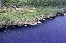
The terrain of Navassa Island consists mostly of exposed coral and limestone, the island being ringed by vertical white cliffs 30 to 50 feet (9.1 to 15.2 m) high, but with enough grassland to support goat herds. The island is covered in a forest of four tree species: short-leaf fig (Ficus populnea var. brevifolia), pigeon plum (Coccoloba diversifolia), mastic (Sideroxylon foetidissimum), and poisonwood (Metopium brownei).[30][31]
Ecology
Navassa Island's topography, ecology, and modern history are similar to that of Mona Island, a small limestone island located in the Mona Passage between Puerto Rico and the Dominican Republic, which were once centers of guano mining, and are nature reserves for the United States.
Transient Haitian fishermen and others camp on Navassa Island, but it is otherwise uninhabited.[30] It has no ports or harbors, only offshore anchorages, and its only natural resource is guano. Economic activity consists of subsistence fishing and commercial trawling activities.[19]
There were eight species of native reptiles, all of which are believed to be, or to have been, endemic to Navassa Island: Celestus badius (an anguid lizard), Aristelliger cochranae (a gecko), Sphaerodactylus becki (a gecko), Anolis longiceps (an anole), Cyclura (cornuta) onchiopsis (a rock iguana), Leiocephalus eremitus (a curly-tailed lizard), Tropidophis bucculentus (a dwarf boa), and Typhlops sulcatus (a tiny snake).[32] Of these the first four remain common with the last four likely extinct.[32] Feral cats, dogs and pigs currently inhabit the island.
In 2012, a rare coral species, Acropora palmata (Elkhorn coral), was found underwater near the island. The remaining coral was found to be in good condition.[33]
Birds
The island, with its surrounding marine waters, has been recognised as an Important Bird Area (IBA) by BirdLife International because it supports breeding colonies of red-footed boobies and magnificent frigatebirds, as well as hundreds of white-crowned pigeons.[34]
Maritime boundary disputes
Due to Haiti's claim of the island of Navassa (which is also supported by Cuba), and subsequently occupied by the United States, the maritime boundaries of Cuba-Haiti-Jamaica are delimited and its meeting points effectively remain in abeyance.[35]
See also
Notes
- "GAO/OGC-98-5 - U.S. Insular Areas: Application of the U.S. Constitution". U.S. Government Printing Office. November 7, 1997. Archived from the original on September 27, 2013. Retrieved March 23, 2013.
- "Navassa Island: The U.S.'s 160-year Forgotten Tragedy | History News Network". historynewsnetwork.org. Retrieved May 14, 2019.
- Spadi, Fabio. "NAVASSA: LEGAL NIGHTMARES IN A BIOLOGICAL HEAVEN?". IBRU Boundary and Security Bulletin, Autumn 2001. p. 116. Archived from the original on December 1, 2017. Retrieved November 22, 2017.
- Constitution de 1874. Port-au-Prince: Haiti.
- An America Territory in Haiti, Posted September 29, 2011, CNN iReport
- Serge Bellegarde (October 1998). "Navassa Island: Haiti and the U.S. – A Matter of History and Geography". windowsonhaiti.com. Archived from the original on October 29, 2007. Retrieved February 6, 2008.
- NA NA, ed. (June 12, 2019). General History of the Caribbean UNESCO Volume 6: Methodology and Historiography of the Caribbean. Springer. p. 846. ISBN 9781349737765. Retrieved May 5, 2020.
- Moreau de Saint Mery, Mederic Louis Elie (1798). "Description topographique, physique, civile, politique et historique de la partie francaise de l'isle Saint Domingue". Moreau de Saint-Mery. p. 741. Retrieved May 5, 2020. (in French)
- Dubois, Laurent (2004). Avengers of the New World: The Story of the Haitian Revolution. Cambridge, Massachusetts: The Belknap Press of Harvard University Press. p. 10.
- Brennen Jensen (March 21, 2001). "Poop Dreams". Baltimore City Paper. Archived from the original on October 25, 2012. Retrieved November 16, 2012.
- https://www.gutenberg.org/cache/epub/5030/pg5030.txt
- John Pike. "Navassa Island Incident 1889-1891". GlobalSecurity.org. Archived from the original on November 2, 2012. Retrieved November 16, 2012.
- "The History Of American Imperialism, From Bloody Conquest To Bird Poop". NPR.org. Retrieved February 22, 2019.
- Russ Rowlett (University of North Carolina at Chapel Hill). "Navassa Island Lighthouse". The Lighthouse Directory. Archived from the original on November 20, 2012. Retrieved November 17, 2012.
- Joe Phillips (November 2, 2005). "Ohio DXers Denied Descheo Island (KP5) Landing Permit". The ARRL Letter Vol 24 No 06. Archived from the original on January 5, 2013. Retrieved November 17, 2012.
- "Navassa Island". Washington, D.C.: U.S. Department of the Interior. Archived from the original on August 15, 2016. Retrieved March 3, 2018.
- "Warren v. United States". Archived from the original on May 17, 2010.
- "Navassa Island". The World Factbook. Central Intellenge Agency. September 10, 2019. Retrieved September 16, 2019.
- "Scientists Give Glowing Report of Untouched Island". Archived from the original on January 4, 2010.
- U.S. Geological Survey (August 2000). "Navassa Island: A Photographic Tour (1998–1999)". U.S. Geological Survey. Archived from the original on November 19, 2012. Retrieved November 18, 2012.
- "Navassa Island: Plan Your Visit". U.S. Fish & Wildlife Service.
- "Navassa NWR Fact Sheet" (PDF). U.S. Fish & Wildlife Service.
- "Navassa Island: Permits". U.S. Fish & Wildlife Service.
- "KP1-5 Project Gets Permission to Activate Navassa Island (KP1) in January 2015". ARRL, the national association for Amateur Radio. October 22, 2014. Archived from the original on October 19, 2015. Retrieved March 31, 2016.
- "K1N Navassa Island DXpedition is Ham Radio History". www.arrl.org. Archived from the original on November 15, 2017.
- Rohter, Larry (October 19, 1998). "Whose Rock Is It? And, Yes, the Haitians Care". The New York Times. Retrieved September 16, 2019.
- Ewan W. Anderson (January 27, 2014). Global Geopolitical Flashpoints: An Atlas of Conflict. Taylor & Francis. pp. 277–. ISBN 978-1-135-94101-7.
- Steven Latta; Christopher Rimmer; Allan Keith; James Wiley; Herbert A. Raffaele, Kent McFarland, Eladio Fernandez (April 23, 2010). Birds of the Dominican Republic and Haiti. Princeton University Press. pp. 9–. ISBN 978-1-4008-3410-5.CS1 maint: multiple names: authors list (link)
- CoRIS - NOAA's coral reef information system. "Navassa Island". National Oceanic and Atmospheric Administration. Archived from the original on November 2, 2012. Retrieved November 16, 2012.
- "Wildlife & Habitat—Navassa Island". U.S. Fish & Wildlife Service. September 7, 2017. Retrieved September 16, 2019.
- Powell, Robert (2003). Reptiles of Navassa Island. Avila University.
- "Archived copy". Archived from the original on October 19, 2017. Retrieved July 20, 2017.CS1 maint: archived copy as title (link) Strangest island in the Caribbean may be a sanctuary for critically endangered coral. Julian Smith. 16 July 2012. Retrieved 11 January 2018.
- "Navassa". BirdLife Data Zone. BirdLife International. 2021. Retrieved January 22, 2021.
- Atlas Caribbean: Maritime Spaces
References
- The Navassa Island Riot. Illustrated. Published by the National Grand Tabernacle, Order of Galillean Fishermen, Baltimore, Md.
- Fabio Spadi (2001). "Navassa: Legal Nightmares in a Biological Heaven?". IBRU Boundary & Security Bulletin. Archived from the original on January 22, 2011.
External links
- Navassa Island at Curlie
- State of Navaza
- A 2014 dissertation entitled Haiti's claim over Navassa Island : a case study
| Sovereign states |
|  | |||||||||||
|---|---|---|---|---|---|---|---|---|---|---|---|---|---|
| Dependencies |
| ||||||||||||
| |
| |
| |
| |
|