Navigation Pass S-1 of Saint Petersburg Dam
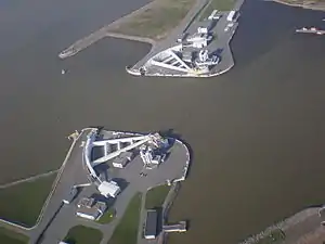
The Navigation Pass S-1 of Saint Petersburg Dam is a storm surge barrier in the eastern part of the Finnish Gulf to the south of the island of Kotlin, Russia. It is part of a waterway from the Baltic Sea to Saint Petersburg located at eastern end of Neva Bay. The scheme of S-1 is similar to the Maeslantkering barrier in the Netherlands and consists of two submersible caissons with dimensions 125×22 metres, which are used to close the navigable channel and thus stop storm tides from proliferating into Neva Bay. The channel is 200 metres wide and 16 metres deep. The Saint Petersburg Ring Road crosses it via an underwater tunnel.
| Wikimedia Commons has media related to Navigation Pass S-1 of Saint Petersburg Dam. |
The construction of the S-1 began in 1984.[1] The S-1 gates were commissioned for exploitation in the middle of 2011. Their first use for the city protection against storm surges happened on 27 November of the same year.[2][3]
Gallery
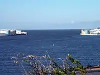 The view of the barrier from the east in June, 2011.
 Construction of the auto tunnel. 14.10.2007
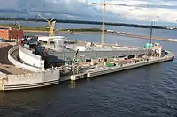 The view on S-1 gate in 2009, two years before their completion.
 Side view
See also
Notes
- Защита Петербурга от наводнений. 2 (500 экз ed.). сост. Щекачихин В. И., Полозов А. В. 2014. p. 51. ISBN 978-5-905107-20-7.
- (in Russian) Мощнейший ураган и наводнение накрыли Петербург: вода угрожает городу (ВИДЕО), Главред, 11/28/2011
- (in Russian) Дирекция КЗС: Дамба предотвратила ущерб в 1,3 млрд рублей