Nebraska Highway 78
Nebraska Highway 78 is a highway in southern Nebraska. It has a southern terminus at the Kansas border where it continues from K-28. Its northern terminus is at an intersection with Nebraska Highway 4 west of Lawrence.
| ||||
|---|---|---|---|---|
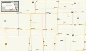 Nebraska Highway 78 highlighted in red | ||||
| Route information | ||||
| Maintained by NDOT | ||||
| Length | 20.02 mi[1] (32.22 km) | |||
| Existed | 1934[2]–present | |||
| Major junctions | ||||
| South end | ||||
| North end | ||||
| Location | ||||
| Counties | Webster | |||
| Highway system | ||||
| ||||

Route description
Nebraska Highway 78 begins at the Kansas border, as a continuation of K-128 south of Guide Rock. The entire route of NE 78 is a straight north–south road through mostly farmland. It heads north from the Kansas border, passing through Guide Rock. To the north of Guide Rock, the highway intersects US 136. It then continues northward until it reaches its termination point at NE 4 west of Lawrence.[1][3]
Major intersections
The entire route is in Webster County.
| Location | mi[1] | km | Destinations | Notes | |
|---|---|---|---|---|---|
| | 0.00 | 0.00 | Continuation into Kansas | ||
| Guide Rock | 6.00 | 9.66 | |||
| | 20.02 | 32.22 | Northern terminus | ||
| 1.000 mi = 1.609 km; 1.000 km = 0.621 mi | |||||
References
- "Nebraska Highway Reference Log Book" (PDF). Nebraska Department of Roads. 2015. p. 199. Retrieved January 7, 2017.
- "The Nebraska Highways Page: Highways 61 to 100". Archived from the original on 2006-12-07. Retrieved 2008-04-06.
- Google (2010-11-01). "overview of Nebraska Highway 78" (Map). Google Maps. Google. Retrieved 2010-11-01.
External links
This article is issued from Wikipedia. The text is licensed under Creative Commons - Attribution - Sharealike. Additional terms may apply for the media files.