Nevada State Route 397
State Route 397 (SR 397) is a state highway in the U.S. state of Nevada. It runs from State Route 860 near Derby Field east on Westergard Road and north on Meridian Road into Lovelock. After passing under Interstate 80/U.S. Route 95, it turns northeast on Amherst Avenue and ends at State Route 398, two blocks southeast of State Route 396 (old U.S. Route 40).
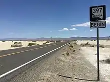
View from the south end of SR 397 looking northbound
| ||||
|---|---|---|---|---|
| Westergard Road, Meridian Road | ||||
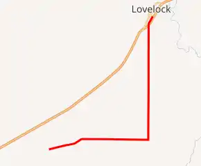
SR 397 highlighted in red | ||||
| Route information | ||||
| Maintained by NDOT | ||||
| Length | 11.840 mi[1] (19.055 km) | |||
| Existed | 1976–present | |||
| History | Created as SR 59 by 1937 | |||
| Major junctions | ||||
| South end | ||||
| North end | ||||
| Location | ||||
| Counties | Pershing | |||
| Highway system | ||||
| ||||

History
Until the 1976 renumbering, most of SR 397 was State Route 59, defined by 1937.[2] At one point, SR 397 only used Westergard Road east of Westfall Road, turning north there to return to I-80/US 95 at Perth.[3] Later, possibly when SR 860 was added, Westfall Road was dropped and SR 397 was extended west to meet SR 860.
Major intersections
The entire route is in Pershing County.
| Location | mi | km | Destinations | Notes | |
|---|---|---|---|---|---|
| | Southern terminus | ||||
| Lovelock | Northern terminus | ||||
| 1.000 mi = 1.609 km; 1.000 km = 0.621 mi | |||||
See also
 United States portal
 U.S. Roads portal
References
| Wikimedia Commons has media related to Nevada State Route 397. |
- Nevada Department of Transportation (January 2017). "State Maintained Highways of Nevada: Descriptions and Maps". Retrieved 2017-04-10.
- "1937 Official Road Map of the State of Nevada". Archived from the original on 2012-02-05. Retrieved 2020-04-16.
- 1984 USGS topographic map
This article is issued from Wikipedia. The text is licensed under Creative Commons - Attribution - Sharealike. Additional terms may apply for the media files.