Neville's Cross
Neville's Cross is a place in County Durham, in England. It is also a ward of Durham with a population taken at the 2011 census of 9,940.[1] It is situated on the A167 trunk road to the west of the centre of Durham.
The area is primarily residential, although there is a newsagent, a Church, some public houses and two primary schools located there. The suburb was also home to part of New College Durham until the college consolidated onto its site at Framwellgate Moor in 2005.[2]
History
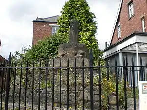
A medieval cross is believed to have stood in the area, presumably erected by, or named for, a member of the influential local Neville family, owners of the Honour of Brancepeth. Neville's Cross would have marked the point where pilgrims approaching Durham from the west, along the old Roman road from Willington and Brancepeth, would have first been able to see Durham Cathedral, the shrine of St Cuthbert. Similar crosses stood by the main roads into Durham from the north (Aykley Heads), east (Sherburn Road Ends), southeast (Philipson's Cross near Mount Joy) and southwest (Charlie's Cross near the New Inn).[3]
Neville's Cross was the site of the Battle of Neville's Cross where in 1346 the English successfully repelled a Scottish invasion force. Knowing that the English army was in France, David II of Scotland invaded England. After pillaging much of Northern England the Scots were met at Neville's Cross by an army of Lancastrians, Yorkshiremen and Cumbrians led by the Archbishop of York. The Scots were defeated by the smaller English army and David II was captured. To commemorate the event a more lavish monument was erected to the south of the battlefield by Ralph Neville, 2nd Baron Neville de Raby.
Neville's Cross became a wealthy residential suburb of Durham late in the 19th century as development extended up Crossgate. Lying in the parish of St Margaret, that church established the mission church of St John, now a parish church in its own right. A teacher training college was built by the county council; this is now converted to university student accommodation. Major growth followed the widening of the Darlington and Newcastle Roads around 1960 to create what is now the A167, bridging the main east coast railway line which had severed Neville's Cross from Crossgate Moor to the north.
References
- "Ward population 2011". Retrieved 13 July 2015.
- "The History of New College Durham". New College, Durham. Retrieved 2011-05-14.
- Historic England. "Neville's Cross (1016622)". National Heritage List for England. Retrieved 23 April 2019.