New York State Route 690
New York State Route 690 (NY 690) is a state highway in Central New York in the United States. NY 690's southern terminus is at an interchange with the New York State Thruway (Interstate 90 or I-90) and I-690 in Van Buren. The northern terminus is at an intersection with NY 48 and NY 631 in Lysander. NY 690 serves the northwest suburbs of Syracuse and Onondaga County. It also provides a link to routes that run into the populated areas of Oswego County, because its northern terminus is just a few miles shy of the county line.
| ||||
|---|---|---|---|---|

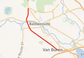
Map of the Syracuse area with NY 690 highlighted in red | ||||
| Route information | ||||
| Maintained by NYSDOT | ||||
| Length | 6.71 mi[1] (10.80 km) | |||
| Existed | July 1, 1974[2]–present | |||
| Major junctions | ||||
| South end | ||||
| North end | ||||
| Location | ||||
| Counties | Onondaga | |||
| Highway system | ||||
| ||||
NY 690 is an extension of I-690 in the northwest suburbs of Syracuse. NY 690 is a divided, four-lane freeway for its entire run, and is signed north–south even though I-690 is signed east–west. NY 690 is one of two state routes that serve as an extension of an Interstate Highway in the Syracuse area, the other being NY 481. NY 690 was designated on July 1, 1974.
Route description
NY 690 officially begins at the exit ramp for I-690 exit 1 in Van Buren, where I-690 ends and NY 690 begins. The route, still a limited-access highway, parallels Van Buren Road to its southeast for a short distance, running from northwest to southeast, before meeting the road northwest of the Thruway by way of an interchange. Outside of Baldwinsville, the road begins to turn to the north as it has an exit for Downer Street Road, which carries NY 31 west of the interchange. North of the exit, NY 31 and NY 690 form a concurrency along the western extents of the village as they cross over the Seneca River.[3]
On the north side of the river in Lysander, NY 31 exits onto NY 370 via a partial clover-leaf interchange. The exit with NY 370 is also the northernmost exit on NY 690. The freeway ends shortly after an at-grade intersection with NY 48 and the northern terminus of NY 631 northwest of Baldwinsville. Although NY 690 ends, the right-of-way of the route continues northward as NY 48 toward Fulton.[3]
History
Construction of what is now NY 690 began in the mid-1960s[4][5] and was completed in the early 1970s.[6][7] The freeway was designated as NY 690 on July 1, 1974.[2] When the expressway was first constructed, the interchange with the New York State Thruway was located south of the Thruway in the space bounded by Winchell Road, Walters Road, I-690, and the Thruway.[8] The Thruway interchange was rebuilt in 1987, locating it about one mile (1.6 km) north to its current location near Jones Road.[9]
Exit list
The entire route is in Onondaga County. All exits are unnumbered.
| Location | mi[1] | km | Destinations | Notes | |
|---|---|---|---|---|---|
| Van Buren | 0.00 | 0.00 | Continuation east as an interstate highway | ||
| Exit 39 on I-90 / Thruway; exit 1 on I-690 | |||||
| 1.81 | 2.91 | Van Buren Road | |||
| 4.24 | 6.82 | Southern terminus of concurrency with NY 31 | |||
| Lysander | 5.14 | 8.27 | Northern terminus of concurrency with NY 31 | ||
| 6.71 | 10.80 | At-grade intersection | |||
1.000 mi = 1.609 km; 1.000 km = 0.621 mi
| |||||
See also
 U.S. roads portal
References
- "2008 Traffic Data Report for New York State" (PDF). New York State Department of Transportation. June 16, 2009. pp. 323–324. Retrieved January 10, 2010.
- State of New York Department of Transportation (July 1, 1974). Official Description of Touring Routes in New York State.
- Google (February 24, 2008). "overview map of NY 690" (Map). Google Maps. Google. Retrieved February 24, 2008.
- New York (Map). Cartography by Rand McNally and Company. Mobil. 1965.
- New York (Map) (1969–70 ed.). Cartography by General Drafting. Esso. 1968.
- New York and Metropolitan New York City (Map) (1969–70 ed.). Cartography by Diversified Map Corporation. Sun Oil Company. 1969.
- New York and New Jersey Tourgide Map (Map) (1972 ed.). Cartography by Rand McNally and Company. Gulf Oil Company. 1972.
- Camillus Quadrangle – New York – Onondaga Co (Map). 1:24,000. 7.5 Minute Series (Topographic). United States Geological Survey. 1978. Retrieved February 15, 2008.
- National Bridge Inventory, a database compiled by the United States Department of Transportation Federal Highway Administration, available at www.nationalbridges.com. Accessed February 15, 2008.
