North Carolina Highway 157
North Carolina Highway 157 (NC 157) is a primary state highway in the U.S. state of North Carolina. The highway runs for 29.3 miles (47.2 km) in a north–south direction from Interstate 85 (I-85)/U.S. Route 15 (US 15)/US 70/US 501 in Durham, to US 158/US 501/NC 57 in Roxboro. The highway serves the cities of Durham and Roxboro, along with the communities of Caldwell and Hurdle Mills. NC 157 is named Guess Road between its southern terminus and Hurdle Mills, and Hurdle Mills Road between Hurdle Mills and the Roxboro city limits. NC 157 does not directly parallel US 501, however, the two highways generally follow a similar alignment between Durham and Roxboro. NC 157 serves the counties of Durham, Orange, and Person.
| ||||
|---|---|---|---|---|
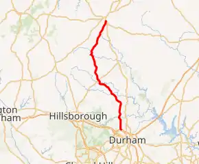
NC 157 highlighted in red | ||||
| Route information | ||||
| Maintained by NCDOT | ||||
| Length | 29.3 mi[1] (47.2 km) | |||
| Existed | 1948–present | |||
| Major junctions | ||||
| South end | ||||
| North end | ||||
| Location | ||||
| Counties | Durham, Orange, Person | |||
| Highway system | ||||
| ||||

Much of the alignment of NC 157 were formerly secondary roads linking Durham, Caldwell, Hurdle Mills and Roxboro. NC 157 was established in 1948 running from NC 57 in Caldwell to US 158/US 501/NC 57 in Roxboro. The route was formerly part of NC 57, which was adjusted in 1948 to follow its current alignment between Caldwell and Roxboro. In April of 1987, NC 157 was extended south along Guess Road from Caldwell to its modern-day southern terminus at I-85. The routing of NC 157 has remained the same since 1987.
Route description
NC 157 begins at a diamond interchange with I-85/US 15/US 70/US 501 (I-85 exit 175) in northern Durham. The highway begins by traveling north along Guess Road. Guess Road also continues south as a secondary road to Club Boulevard. North of the interchange, the adjacent properties are primarily commercial businesses. Several intersecting streets lead to residential neighborhoods. Beginning at Ellen Street, the properties along NC 157 change from commercial to residential buildings. As NC 157 continues north, it intersects Horton Road where several shopping centers and strip malls are located. North of the intersection, NC 157 turns to the northwest and passes a Durham County Correctional Facility located to the east. NC 157 continues for one-half mile (zero point eight zero kilometres) northwestward before turning to the northeast and crossing the Eno River. As NC 157 continues north of Durham, it runs through the suburbs and exurbs in northern Durham County. North of the Eno River, the surroundings become increasingly rural as the highway runs adjacent to many residential neighborhoods with forested areas. NC 157 makes a turn to the northwest near Milton Road, an orientation it maintains until reaching Caldwell. The highway briefly runs adjacent to and crosses the South Fork Little River. North of the river crossing, the surrounding area transforms from residential neighborhoods to rural farmland and forested area. NC 157 continues 0.3 miles (0.48 km) northwest of the river before crossing into Orange County.[1][2]
After crossing into Orange County, NC 157 runs adjacent to the Little River Regional Park and Natural Area. NC 157 generally continues to the northwest, with several curves that adjust its orientation. The highway crosses the North Fork Little River south of Caldwell before turning northward toward Caldwell. NC 157 meets NC 57 at an at-grade intersection in the unincorporated community of Caldwell. Between Caldwell and Barry Road, NC 157 generally follows a northerly alignment. At Barry Road, NC 157 diverges to the northwest, continuing to follow Guess Road. NC 157 enters Person County 0.7 miles (1.1 km) northwest of Barry Road. After crossing into Person County, NC 157 continues to follow a northwestward orientation until reaching Hurdle Mills. Nearing Hurdle Mills, the highway runs adjacent to residential neighborhoods on the southeastern side of the community. NC 157 also begins to generally parallel the Flat River located to the northeast of the highway. The highway enters Hurdle Mills from the southeast, intersecting Hurdle Mills Road at an at-grade T-intersection. At the intersection, NC 157 turns to the northeast to follow Hurdle Mills Road toward Roxboro. As it exits the community, NC 157 crosses the Flat River. North of Hurdle Mills, the highway primarily runs through a rural area with several farms and multiple forested areas. As NC 157 approaches Roxboro, it runs adjacent to several residential neighborhoods located near the highway. Southwest of Roxboro, the highway meets Wrenn Crumpton Road/Paterson Drive at a four-way stop intersection. Wrenn Crumpton Road runs west to NC 49 while Paterson Drive runs east to US 501/NC 57. As NC 157 enters into Roxboro from the southeast, the road name changes from Hurdle Mills Road to Main Street. The highway continues for one mile (one point six kilometres) through a residential area of southern Roxboro. The northern terminus of NC 157 is located at an intersection with US 158/US 501/NC 57 south of downtown Roxboro.[1][2]
History
By 1930, the roads which comprise-modern day NC 157 existed as secondary roads. A section of modern-day Guess Road between Durham and Horton Road was paved by 1930. The remaining roads were either graded, gravel, or unimproved roads.[3][4][5] By 1935, NC 57 was signed along secondary roads from Hillsborough to Roxboro. NC 57 followed its modern alignment between Hillsborough and Caldwell, and then followed modern-day Guess Road and Hurdle Mills Road to Roxboro. In 1935, the entirety of NC 57 was classified as a gravel or topsoil road.[6] By 1936, NC 57 between Hillsbourgh and Roxboro was considered a hard-surface road on county maps, but was not paved according to the 1936 state transportation map.[7][8][9] By 1940, NC 57 was paved between Hillsbourough and the South Fork Little River and between Hurdle Mills and Roxboro.[10] By 1944, much of modern-day NC 157 was paved. Guess Road between Durham and Crooked Creek in Durham County was classified as a "high-type" paved road. Two segments, one between Crooked Creek and Caldwell and another between Hurdle Mills and Roxboro were a bituminous surface road. The segment of highway between Caldwell and Hurdle Mills remained a graded road.[11][12][13] NC 57 was relocated north of Caldwell in 1948. From Caldwell NC 57 continued northeast until reaching US 501 north of Rougemont. From the intersection, NC 57 ran concurrently with US 501 to Roxboro.
NC 157 was established along the former alignment of NC 57 running along Guess Road and Hurdle Mills Road from Caldwell to Roxboro. The southern terminus was located at NC 57 in Caldwell and the northern terminus was located at US 158/US 501/NC 57 in Roxboro. Much of NC 157 was paved at the time of its establishment, with the exception of a segment between Caldwell and the Orange County–Person County line.[14][15] By 1951, all of NC 157 was paved with the completion of the Caldwell to Person County segment.[16] On April 13, 1987, NC 157 was extended south by 14.2 miles (22.9 km) to Durham. The southern terminus of NC 157 was moved to I-85 in Durham and NC 157 followed Guess Road to Caldwell.[17] The routing of NC 157 has remained the same since 1987.[2]
Major intersections
| County | Location | mi[1] | km | Destinations | Notes |
|---|---|---|---|---|---|
| Durham | Durham | 0.0 | 0.0 | Southern terminus; exit 175 (I-85); diamond interchange | |
| Orange | Caldwell | 14.2 | 22.9 | ||
| Person | Roxboro | 29.3 | 47.2 | Northern terminus | |
| 1.000 mi = 1.609 km; 1.000 km = 0.621 mi | |||||
References
- Google (April 14, 2016). "North Carolina Highway 157" (Map). Google Maps. Google. Retrieved April 14, 2016.
- North Carolina Department of Transportation; North Carolina State Tax Commission (2019). State Transportation Map (Map) (2019–2020 ed.). North Carolina Department of Transportation.
- North Carolina State Highway Commission (1930). Durham County (PDF) (Map). North Carolina State Highway Commission.
- North Carolina State Highway Commission (1930). Orange County (PDF) (Map). North Carolina State Highway Commission.
- North Carolina State Highway Commission (1930). Person County (PDF) (Map). North Carolina State Highway Commission.
- Sawyer, C.M. (1935). State highway system of North Carolina (Map). Raleigh: North Carolina State Highway and Public Works Commission.
- North Carolina State Highway and Public Works Commission (1936). Orange County (PDF) (Map). North Carolina State Highway and Public Works Commission.
- North Carolina State Highway and Public Works Commission (1936). Person County (PDF) (Map). North Carolina State Highway and Public Works Commission.
- Sawyer, C.M. (1936). State highway system of North Carolina (Map). Raleigh: North Carolina State Highway and Public Works Commission.
- North Carolina State Highway and Public Works Commission (1940). North Carolina Primary Highway System (Map) (1940 ed.). 1:823,680. North Carolina State Highway and Public Works Commission.
- North Carolina State Highway and Public Works Commission (1944). Durham County (PDF) (Map). North Carolina State Highway and Public Works Commission.
- North Carolina State Highway and Public Works Commission (1944). Orange County (PDF) (Map). North Carolina State Highway and Public Works Commission.
- North Carolina State Highway and Public Works Commission (1944). Person County (PDF) (Map). North Carolina State Highway and Public Works Commission.
- North Carolina primary highway system (Map) (1946-1947 ed.). Cartography by C.M. Sawyer. Winston-Salem, N.C.: Winston Ptg. Co. 1946.
- North Carolina primary highway system (Map) (1948-1949 ed.). Cartography by C.M. Sawyer. Winston-Salem, N.C.: Winston Ptg. Co. 1948.
- North Carolina primary highway system (Map) (1951 ed.). 1:823,680. Cartography by North Carolina State Highway and Public Works Commission. Winston-Salem, N.C.: Winston Ptg. Co. 1951.
- "Route Changes (1987-04-13)" (PDF). North Carolina Department of Transportation. April 13, 1987. Retrieved December 22, 2020.