North Carolina Highway 67
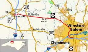
North Carolina Highway 67 (NC 67) is a 40.9-mile-long (65.8 km) primary state highway in the U.S. state of North Carolina. It serves mostly the northern area of Yadkin County, connecting the towns of Jonesville, Boonville and East Bend, along with the city of Winston-Salem in Forsyth County.
| ||||
|---|---|---|---|---|
 | ||||
| Route information | ||||
| Maintained by NCDOT | ||||
| Length | 40.9 mi[1] (65.8 km) | |||
| Existed | 1930–present | |||
| Major junctions | ||||
| West end | ||||
| East end | ||||
| Location | ||||
| Counties | Yadkin, Forsyth | |||
| Highway system | ||||
| ||||
Route description
The western terminus is U.S. Route 21 Business in Jonesville. From this point in Yadkin County, the route travels in an easterly direction over Interstate 77, through Boonville and East Bend before crossing the Yadkin River into Forsyth County.
After crossing the county line, NC 67 turns to head in a southeasterly direction through part of Tobaccoville, and near Bethania and Pfafftown on its way into Winston-Salem. Once within Winston-Salem's city limits, the route bears the street name Reynolda Road on its straight southeasterly journey toward downtown. After passing the Silas Creek Parkway overpass bridge, NC 67 arrives at the Wake Forest University campus, NC 67 bears right onto a short 1⁄4-mile-long (0.40 km) road known as Wake Forest Road, which is a connecter to Silas Creek Parkway. After it connects with Silas Creek Parkway, it passes an interchange with Robinhood Road. It also passes another interchange with Country Club Road. After passing an intersection with Goodyear Drive, it turns into a short expressway with a Cloverleaf interchange with Salem Parkway (US 421). The road becomes a boulevard after passing the Stratford Road (US 158) interchange. It goes into the Hanes Mall area. NC 67 passes another interchange with Bolton Street. The road passes a bunch of intersections around the Forsyth Tech area. The eastern terminus of NC 67 is at an intersection with Peters Creek Parkway (NC 150).
History
- 1930 - NC 67 was formed as a new primary route. It ran from US 21/NC 26 Jonesville to US 421/NC 60 (now Old Yadkinville Rd) in Oldtown.
- About 1933 - NC 67 was given its much straighter alignment from Jonesville to then-US 421.
- Early 1950s - NC 67 was placed on a bypass south of East Bend, leaving behind "Old NC 67."
- Around 1962-1963 - NC 67 was extended into central Winston-Salem replacing US 421. It ran down Reynolda Road, West End Boulevard, and Broad Street then used one-way splits on 4th-5th Street over to US 158 Business (used one-way splits on Cherry Street-Marshall Street).
- 1970 - NC 67 was removed off 4th/5th Street and instead continued south on Broad Street to end the at the interchange with what would later become Salem Parkway.
- 1991 - NC 67 was removed from the Reynolda Road routing to downtown Winston-Salem and was rerouted onto the four-lane expressway Silas Creek Parkway between the Reynolda Road interchange and NC 150 at-grade intersection.
Major intersections
| County | Location | mi[1] | km | Destinations | Notes |
|---|---|---|---|---|---|
| Yadkin | Jonesville | 0.0 | 0.0 | ||
| 1.4– 1.6 | 2.3– 2.6 | Exit 82 (I-77) | |||
| Boonville | 7.8 | 12.6 | |||
| Forsyth | Winston-Salem | 33.6 | 54.1 | Silas Creek Parkway north | Western end of Silas Creek Parkway overlap |
| Forsyth | Winston-Salem | 35.3– 35.6 | 56.8– 57.3 | Robinhood Road | Interchange |
| 36.8– 36.9 | 59.2– 59.4 | Country Club Road | Interchange; Westbound NC-67 via Tiseland Drive | ||
| Begin expressway | |||||
| 37.4– 37.7 | 60.2– 60.7 | Exits 237 A-B (US-421) | |||
| 37.9– 38.1 | 61.0– 61.3 | Folded diamond interchange | |||
| End expressway | |||||
| 38.8– 39.0 | 62.4– 62.8 | Bolton Street | Folded diamond interchange | ||
| 40.9 | 65.8 | Eastern end of Silas Creek Parkway overlap | |||
| 1.000 mi = 1.609 km; 1.000 km = 0.621 mi | |||||
References
- Google (May 5, 2015). "North Carolina Highway 67" (Map). Google Maps. Google. Retrieved May 5, 2015.