North Carolina Highway 79
North Carolina Highway 79 (NC 79) is a primary state highway in the U.S. state of North Carolina running from the South Carolina border at Gibson to U.S. Route 15 (US 15), US 401, US 501, and US 74 Business in Laurinburg. While signed north–south, NC 79 physically travels in an east–west direction between its termini. Combined with South Carolina Highway 79 (SC 79) which adjoins NC 79 at its southern terminus, the highways form a coherent route between SC 9 and Laurinburg.
| ||||
|---|---|---|---|---|
| Gibson Road | ||||
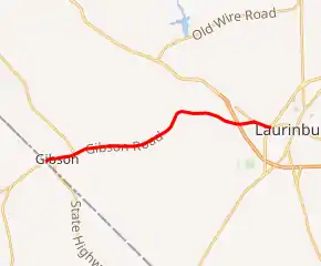
NC 79 highlighted in red | ||||
| Route information | ||||
| Maintained by NCDOT | ||||
| Length | 8.7 mi[1] (14.0 km) | |||
| Existed | 1935[2]–present | |||
| Major junctions | ||||
| South end | ||||
| North end | ||||
| Location | ||||
| Counties | Scotland | |||
| Highway system | ||||
| ||||

A state highway between South Carolina and Laurinburg was first established in 1921 as North Carolina Highway 203. Originally, NC 203 traveled between South Carolina and NC 20 through Gibson. NC 203 was subsequently renumbered as NC 79 by 1935. Originally, NC 79 ran between South Carolina and US 74 (modern-day US 74 Business) west of Laurinburg. In 1966, NC 79 was extended east along US 74 to its modern-day northern terminus at US 15/US 401.
Route description
NC 79 begins at the North Carolina–South Carolina state line west of Gibson. The highway continues southwest into South Carolina as South Carolina Highway 79 (SC 79) toward Cheraw. NC 79 begins by running northeast along Main Street toward central Gibson. At Francis Street, NC 79 makes a slight turn to the east, an orientation which it follows through Gibson. NC 79 meets NC 381 at Church Street. The intersection is the beginning of a concurrency between NC 79 and NC 381 that continues through Gibson. NC 79/NC 381 crosses a railroad line operated by CSX Transportation 450 feet (140 m) to the east of Church Street.[3] Continuing east along Main Street, NC 79 and NC 381 largely pass through a residential area of Gibson. East of Gibson, the NC 79/NC 381 concurrency ends at an intersection with Hamlet Road. NC 381 continues to the northwest toward Hamlet while NC 79 continues east toward Laurinburg. NC 79 continues along Main Street until leaving the Gibson city limits, where it is renamed Gibson Road.[1][4]
East of Gibson, NC 79 continues through a rural area of Scotland County, with sparse residential areas, farms, and forested areas adjacent to the highway. In addition, several residential communities are located near the state highway. NC 79 crosses Joes Creek, which drains to the Little Pee Dee River before making a slight turn to the northeast. The highway crosses Lower Beaverdam Creek and makes another northeasterly turn. As NC 79 approaches Rockingham Road, it begins a turn to the east, which is completed immediately east of Springs Mill Road. Approaching Laurinburg, NC 79 makes a slight southeasterly turn, an orientation the highway follows for the remainder of its route. NC 79 meets US 74 at an incomplete interchange west of Laurinburg. The highway continues for 0.5 miles (0.80 km) to the east along Gibson Road until meeting US 74 Business at an at-grade intersection. At the intersection, NC 79 and US 74 Business begin a concurrency to the east. The highways continue for 0.7 miles (1.1 km) through a residential area of western Laurinburg until reaching US 15/US 401/US 501 at diamond interchange. The northern terminus of NC 79 is located at the interchange.[1][4]
The North Carolina Department of Transportation (NCDOT) measures average daily traffic volumes along many of the roadways it maintains. In 2016, average daily traffic volumes along NC 79 varied from 1,900 daily vehicles between the South Carolina line and NC 381 to 8,100 at Forest Road in Laurinburg.[5]
History
In 1916 and 1918, North Carolina prepared a planned system of state highways consistent with the Federal Aid Road Act of 1916. The routing of NC 79 did not appear on either plan.[6][7] By 1920, an improved road existed linking South Carolina to Laurinburg via. Gibson and Springfield.[8] Upon the creation of the North Carolina State Highway System in 1921, much of the modern-day routing was signed as portions of NC 20 and NC 203.[9]
North Carolina Highway 203
| |
|---|---|
| Location | SC State Line–Laurinburg |
| Length | 8.0 mi[10] (13 km) |
| Existed | 1921[9]–1935[2] |
North Carolina Highway 203 (NC 203) was an original state highway that traversed from the South Carolina state line, at Gibson, to NC 20. In 1922, the northern terminus of NC 203 was located west of Laurinburg at the modern-day intersection with Springs Mill Road.[11] By 1926, NC 20 was realigned between Laurinburg and Laurel Hill to follow a more direct route. NC 203 was extended east to NC 20 between Laurinburg and Laurel Hill.[12] NC 203 was adjusted to run further east by 1929, ending at US 74/NC 20 two miles (three point two kilometres) west of Laurinburg.[13] By 1935, NC 203 was renumbered as NC 79.[10][2]
Establishment
NC 79 first appeared on North Carolina state transportation maps in 1935 running from the South Carolina state line near Gibson to US 74 (modern-day US 74 Business) in Laurinburg. At the time of establishment, NC 79 was a paved highway.[2] The routing of NC 79 remained consistent until January 7, 1966. In 1966, the northern terminus of NC 79 was extended 0.6 miles (0.97 km) from US 74 to a newly completed US 15/US 401 freeway in Laurinburg. The extension was concurrent with US 74 for its entire length.[14] US 74 was routed onto a new freeway south of Laurinburg in November of 1984. The former route, including the NC 79 concurrency became US 74 Business.[15]
Major intersections
The entire route is in Scotland County.
| Location | mi[1] | km | Destinations | Notes | |
|---|---|---|---|---|---|
| Gibson | 0.0 | 0.0 | South Carolina state line; Southern terminus | ||
| 0.3 | 0.48 | Southern end of NC 381 concurrency | |||
| 1.1 | 1.8 | Northern end of NC 381 concurrency | |||
| | 7.5 | 12.1 | Exit 182 (US 74), eastbound entrance / westbound exit only; future I-74 | ||
| | 8.0 | 12.9 | Western end of US 74 Bus. concurrency | ||
| Laurinburg | 8.7 | 14.0 | Northern terminus; Diamond interchange; eastern end of US 74 Bus. concurrency | ||
1.000 mi = 1.609 km; 1.000 km = 0.621 mi
| |||||
See also
- U.S. Bicycle Route 1-Concurrent with NC 79 in Springfield
References
- Google (December 28, 2012). "North Carolina Highway 79" (Map). Google Maps. Google. Retrieved December 28, 2012.
- Sawyer, C.M. (1935). State highway system of North Carolina (Map). Raleigh: North Carolina State Highway Commission.
- North Carolina Department of Transportation (2017). North Carolina Rail Operators and Branches (PDF) (Map). North Carolina Department of Transportation.
- North Carolina Department of Transportation; North Carolina State Tax Commission (2019). State Transportation Map (Map) (2019–2020 ed.). North Carolina Department of Transportation.
- North Carolina Department of Transportation Management Systems and Assessments Unit (2016). Scotland County, North Carolina (PDF) (Map) (2016 ed.). North Carolina Department of Transportation.
- North Carolina State Highway Commission (1916). Highway map of North Carolina prepared by the North Carolina State Highway Commission for the five year federal aid program (Map). 1:696,960. Raleigh: North Carolina State Highway Commission.
- North Carolina State Highway Commission (1918). Highway map of North Carolina prepared by the North Carolina State Highway Commission for the five year federal aid program (Map). 1:2,027,520. Raleigh: North Carolina State Highway Commission.
- North Carolina (PDF) (Map). Cartography by North Carolina State Highway Commission. North Carolina State Highway Commission. 1920. Retrieved January 8, 2021.
- Map of North Carolina State Highway System (PDF) (Map). Cartography by North Carolina State Highway Commission. North Carolina State Highway Commission. 1921. Retrieved January 8, 2021.
- North Carolina State Highway Commission (1933). State Highway System of North Carolina (Map) (1933 ed.). 1:887,040. Cartography by C.M. Sawyer. Raleigh: North Carolina State Highway Commission.
- State Highway System of North Carolina (PDF) (Map). Cartography by North Carolina State Highway Commission. North Carolina State Highway Commission. 1922. Retrieved January 8, 2021.
- North Carolina State Highway Commission (1926). The State Highway System of North Carolina (Map) (1926 ed.). Raleigh: North Carolina State Highway Commission.
- North Carolina State Highway Commission (1929). State Highway System of North Carolina (Map). Raleigh: North Carolina State Highway Commission.
- "Route Changes (1966-01-07)" (PDF). North Carolina State Highway Commission. January 7, 1966. Retrieved January 8, 2021.
- "Route Changes (1984-11-01)" (PDF). North Carolina Department of Transportation. November 1, 1984. Retrieved January 8, 2021.
External links
 Media related to North Carolina Highway 79 at Wikimedia Commons
- NCRoads.com: N.C. 79