North East Green Belt
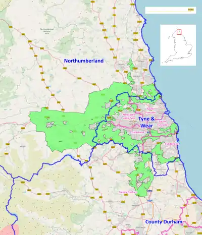
The North East Green Belt, also known as the Tyne & Wear Green Belt, is a non-statutory green belt environmental and planning policy that regulates the rural space in part of the North East region of England. It is centred on the county of Tyne and Wear,[1][2][3][4] with areas of belt extending into Northumberland[5] and County Durham.[6] The belt functions to protect surrounding towns and villages outside the Tyneside/Newcastle-upon-Tyne and Wearside/Sunderland conurbations from further convergence.[7] It is managed by local planning authorities on guidance from central government.
Geography
The belt's area is 71,854 hectares (718.54 km2; 277.43 sq mi), 0.6% of the total land area of England (2010).[8] The belt is on the fringes of the Tyne & Wear conurbations, with a line of belt separating South Tyneside from Sunderland. The main coverage of the belt however, is within southern Northumberland, with tracts in northern County Durham, notably surrounding the city of Durham completely.
Much of the boundary is formed by local roads and land features such as rivers. The western extent reaches 25 miles away from Newcastle, beyond Hexham and towards Haydon Bridge, becoming contiguous with the North Pennines AONB and nearly meeting the Northumberland National Park. Due to the belt lying across county borders, responsibility and co-ordination lies with several unitary councils as these are the local planning authorities.
See also
References
- "Planning for the Future Core Strategy and Urban Core Plan for Gateshead and Newcastle upon Tyne 2010-2030 Adopted March 2015" (PDF). www.newcastle.gov.uk.
- "North Tyneside Council Green Belt Review October 2015" (PDF). my.northtyneside.gov.uk.
- "South Tyneside Green Belt and Landscape Background Paper September 2012" (PDF). www.southtyneside.gov.uk.
- "SUNDERLAND GREEN BELT REVIEW STAGE 1 – CORE STRATEGY GROWTH OPTIONS STAGE, MARCH 2016" (PDF). www.sunderland.gov.uk.
- "Northumberland Local Plan Core Strategy - Full draft plan Draft for Policy Board - 27 November 2014" (PDF). www.nandnsociety.org.
- Collinson, Rachel. "The creation of the North Durham Green Belt". planninghelp.cpre.org.uk.
- Fawcett, Tony. "Green Belts: A greener future - Campaign to Protect Rural England". Archived from the original on 27 June 2018. Retrieved 28 December 2017.
- "Green Belts in England: Key facts - A series of factsheets on England's 14 Green Belts".